Denali, Cassin Ridge
By: Mark Anderson | Climbers: Mark Anderson, Mike Anderson |Trip Dates: May 14 - June 1, 2001
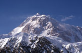
Photo: Kim Grandfield
® The author(s) and naclassics.com | ![]() Back to climb page
Back to climb page ![]() NAC Home page
NAC Home page
|
|
Denali, Cassin Ridge By: Mark Anderson | Climbers: Mark Anderson, Mike Anderson |Trip Dates: May 14 - June 1, 2001 |
|
Photo: Kim Grandfield |
® The author(s) and naclassics.com | |
|
Synopsis: The general plan was as follows: Acclimatize on the W Butt up to 17 or 18k, with base camp at 14K. When it looked like the weather would be adequate for 3-4 days, we would climb the W Rib Cutoff from Genet Basin to the W Rib, then down climb/rappel the W Rib or the Wickwire to the NE Fork of the Kahiltna Glacier. From the NE Fork we would climb the Cassin alpine style as fast as possible, descend via the West Buttress. The weather was generally very good, we spent 3 days in the tent at 14K waiting for weather (the rest were spent waiting for motivation). Our acclimatizing schedule was very ambitious and is NOT recommended for anyone (although I intend to follow the same schedule if there ever is a next time). Our plan to down climb the Rib worked very well, but may be time consuming for more safety conscious parties. In a broad sense, considering objective hazards, down climbing the Rib w/ no gear was probably safer (for us) than climbing up the NE Fork would have been. We moved much slower than expected while on the Cassin, although we did make very steady progress. We brought way too much food, but about the right amount of fuel (brought 60oz, used 40oz). We found the ice climbing to be very easy (I never got pumped)-the ice was totally plastic (not at all "bullet proof"). The mixed climbing was easy, but very awkward with a pack, since all the cruxes are short chimneys. Make sure you have a low profile pack with no poles sticking out. I got my collapsible ski pole stuck while trying to surmount the Bergschrund (at the base of the Japanese Couloir) with near disastrous results. There is a lot of fixed gear on the route, and if you have a keen eye for spotting fixed line, you should have few route finding problems. We only got off route once, just below the end of the 2nd Rock Band. Take a good look at the Andy DeKlerk topo (c. 1989) in the Talkeetna Ranger Station for detailed beta on this section. This route requires a great deal of determination. There is a large magnet/black hole that tries to suck would-be alpinists west onto the Butt. I was very nearly lulled into it myself, especially once the weather got marginal. Once on the route, the climbing is truly excellent. Very moderate, but very fun and interesting. This was the most interesting ice climbing I've ever done; for the first time I never got bored of the ice (except on the Ice Rib which goes on forever). I highly recommend the route, and our approach worked very well, except that, for motivational reasons, I would avoid spending a lot of time (and getting too comfortable) at 14K on the Butt. 14 May: Landed @ KIA @ approx. 7pm. Rico from TAT gave us the "route preview" which was more of a "lower half of the NE Fork Preview." A serious ripoff for $150 ($50/climber). Of course by this time we were pretty well accustomed to being screwed by Alaskan Bush Pilots. We made our flight reservation with TAT back in March. When we showed up at TAT at noon today they said they might be able to "squeeze" us in at 8pm. Five minutes later a gaggle of tourists stroll in with no reservation and they were in the air 45 minutes later for a "flightseeing tour." We got the same treatment from Doug Geeting two years prior, but I expected a little more from the crew that advertises "Climbers are our primary concern and focus." Maybe they mean "famous climbers…." We are by very nature rather impatient men, so our plan (according to Mark Twight), was to get to 14K on the Butt as fast as possible. This required us to get as close as possible to 11k on the first day. Thanks to TAT, the first day was now the first night, but we couldn't afford to spend any more time at such a low altitude. We had spent the previous four nights stateside (lower 48 for all you Alaskans) acclimatizing at 10.5k, 10.5k, 12.5k, and 10.5k respectively. Last night was spent in Anchorage at sea level, so we had no time to spare. As soon as we landed we rigged our packs and sleds for the long haul. We skied with much difficulty until 2am, when it was simply to cold for us to continue. A tip for neophytes: figure out your sled system before you leave home. Go out in the snow some weekend and practice hauling 125 lbs of bulky, poorly balanced crap and find out how much it sucks! Then figure out how to make it work better. We had made it to roughly 9.3k. Not great, but acceptable. We were far enough along that we might be able to move to 11k and carry to 14K tomorrow. We set up our big tent in frigid temps, and shivered the night away. We were up till 5am while Mike brewed and cooked for us. 15 May: Got up around 10am, with the tourists already up and skiing past our tent. We slowly worked our way to 11k, where we cached our sleds and skis, set up our tent and began brewing. We figured we'd rest as long as necessary, then haul our sled loads up to 14K. Left at 7:15pm for the light haul. With our more appropriate alpine loads we made it to 13.2k (Windy Corner) by 10pm, dug a pit and were back at the tent at 11:30pm. 16 May: Finished the slog to 14K. Took 3.5 hours. Found the only available shelter and dug in. Mike wasn't feeling great so we put off our back-carry until tomorrow. 17 May: Got up at 10, sat around in the sun until 1pm. Left for our back carry at 2pm, got back to 14K around 4pm. 18 May: Sat on our butts more or less all day. 19 May: Today the plan was to scout out the approach to the W Rib. There was a set of tracks leading up the W Rib cutoff that might be helpful, but the party that left them was obviously heading up once they reached the Rib. We were heading down, so our goal was to hit the Rib as low as possible, so we would have to break our own trail most of the way. We had very little beta on this W Rib down climb maneuver we were attempting. Fred Beckey's "Icey Crown of N America" gives a vague description of a boulder that marks the descent from the Rib to Genet Basin. Secor's "Denali Climbing Guide" offers a nearly useless description of the W Rib cutoff, stating that the climber can join the Rib somewhere between 15.5 and 16.5K. We figured to scout out and wand the route on an acclimatization day so we would know ahead of time where to go (and maybe we'd have tracks to follow as well once we were carrying packs). Shortly after we left camp we ran into two dudes from Dartmouth heading down the cutoff. They had left 2 hours earlier from 14K, and turned around at 15.5k citing "extreme avalanche hazard." One of them was aloof, the other was named Jeff, and by the way he dropped names, you'd think he was best friends with every climber from here to Chamonix. Anyway, Mike and I have never been the sort to follow intelligent advice, so we carried on anyway, breaking off to the right (east) of their tracks. They weren't really heading where we wanted to anyway, and we thought maybe the "extreme hazard" would be less severe over to the right. We crossed 2 minor crevasses above the massive ice fall that marks the east edge of Genet Basin, and hit the Rib at roughly 3:30pm. There was a stiff wind ripping over the ridge, so we snapped a couple quick photos, marveled shortly at the Cassin, and headed back towards the tent. According to my altimeter, the lowest possible altitude one could join the W Rib (without traversing seriously serious terrain) is 15,670. The low-point is marked by an obvious boulder sticking out from the Rib, just as Jeff's good buddy 'Fred' had described. 20 May: Rest day. Spent most of the day anchoring our tent to the mountain in anticipation of the extreme wind everyone had warned us about. So far the only wind we found was the refreshing breeze on the Rib [I bet you thought I was gonna make some joke about farting, didn't you!], but since we planned to leave the tent unattended for 4-5 days while we were on the Cassin we figured we ought to strap her down just in case. 21 May: Today was the first predicted day of poor weather. Winds 30-40 mph up at 17K. Today was also the day we planned to acclimatize up the Butt to 17 or 18k, and since we're alpinists we're always in a big hurry so we decided to go anyway. The climbing was far more interesting than I expected. We didn't use the fixed lines at all on the way up or down, mostly because there was a long line, but partly because it seemed kinda like cheating to me. [I don't wanna start some ethical debate-you play by your own rules, and I'm not judging anyone else, I just think that for me personally, I would have felt weird using the fixed lines. On the other hand, I used them on the way down from the Cassin, and I jugged the first 4 pitches of the Nose, so now who's the hypocrite?] Anyway, the Butt above the fixed lines was interesting, and it was nice to see some rock for a change. We stopped at 17K for an hour to "practice" brewing. Our training session revealed many valuable lessons, primarily that brewing at 17K in the wind sucks. We hiked back down to 14K, all prepped to hit the Cassin as soon as we got some good weather. 22 May: As my clever foreshadowing implied, the weather has turned. Its not super heinous, just overcast with scattered snow showers all day, and winds higher up. We spent the day illin' in our crib (that means sitting in the tent, for the over 40 crowd) 23 May: Another day in the tent. We actually got up at 8am and got all dressed and ready to go and then we got out of the tent and could see spindrift sailing west across the Rib at a pretty good clip so we decided to bag it and wait for less wind and warmer temps. Today was the first day in either of our lives that we had waited for weather to climb. 24 May: In the tent some more. 25 May: Last day in the big tent! 26 May: Left the 14K camp at around 10am for the W Rib. The weather hadn't really improved that much, we were just sick of waiting. The weather was expected to improve around the 29th & 30th, which would be around our summit time, so that was good enough for us. Our tracks to the Rib were completely filled by the 1-2 feet of snow we got over the last 4 days. The wands were helpful with route finding. I was in the lead today, and the snow was such that I pretty much had to dig a trench with my legs to move upward. It took us 4.5 hours to get to the Rib at 15.7K. Not exactly stellar time. There was a slight wind blowing across the Rib, but nothing serious. Mike lead down the Rib, which turned out to be much more interesting than expected. We agreed the Rib would be a worthwhile climb in itself. The descent began with 50 feet of 3rd Class mixed terrain, which gave way to miles of ice and snow. We down climbed to 13K on the rib, atop the "First Ice Dome." The climbing was generally low angle ice (30-40 degree) covered by 6-12 inches of snow. We hit camp around 7:30 pm. We definitely could have gone farther, but I wasn't feeling well. We were surprised to see a group of 3 climbers fixing their way up the Rib. 27 May: Had a nice chat with the Ribbers while we packed up our camp. They called themselves "siege monsters." They had 700 feet of fixed line that they were using to inchworm their way up the route. They had fixed the route more or less from our camp down to the top of the crux couloir and offered to let us rap their lines. Mike commented that it was nice to finally meet some climbers with enough creativity to climb something other than the Butt. I was definitely shocked, when on the Butt, to see how many good climbers were content with following everybody else. There are numerous quality routes in the area such as the upper West Rib, Orient Express, or Messner Couloir that are virtually ignored. Most of the climbers on the Butt are reasonably skilled mountaineers that could easily manage any of these lines. Its almost as if it had just never occurred to them to climb something different. Anyway, we didn't end up using the fixed lines at all, since that would have slowed us down. We made it from the top of the 1st ice dome at 13K to the bottom of the Rib at 11.2K in 1 hour and 45 minutes. Not too bad, I was starting to feel alpine. Next was a mile long trudge up the remainder of the NE Fork, to the base of the Japanese Couloir. About halfway through the Valley I walked slowly across a sun-baked snow bridge that slowly gave way. I fell about 20 feet before the rope caught me. Fortunately I was wearing my helmet, but little else. The snow had been balling up like crazy so we both removed our crampons, and my second ice tool was also strapped to my pack. It was blistering hot outside, so I was only wearing a light weight polypropylene t-shirt; no gloves or hat. The snow bridge more or less landed on top of me, so I was instantly drenched in snow. For the first five minutes I was freezing cold, but as the fear sank in, and I started trying to fight my way out, I warmed up quickly. After 15minutes of struggling I managed to remove my pack without dropping anything except my sunglasses and my camelback. No worries, I had spares of both. I had removed my 2nd tool, and was in the process of attaching my crampons when the rope began steadily tugging me upward. Two minutes later I was back in the land of the living, enjoying the blazing sun. I snapped a couple photos of the crevasse, then we took a nice long rest before pressing on. Another half hour of slogging put us 200 feet below the bergschrund. We suited up for the ice and mixed climbing that waited, and Mike set off. The couloir begins by surmounting the bergschrund, which can be quite awkward with a pack. Next follows 300 feet of steep (60degree), hard, and brittle ice. This section was very hard on the calves. Above this section the couloir tends to collect more snow, which was far easier on our legs. We generally didn't have to do more than 50 feet of pure front pointing without good long rests in snow. After 200 more feet or so the route splits. You can climb right over 20-30 feet of near vertical water ice, or left over "easy" mixed ground. Our calves demanded that we climb left, over the mixed terrain. I found this section to be very strenuous, some of the most difficult mixed climbing on the route. I think the ice on the right would have been much easier. Above this is 500 more feet of moderate ice and snow climbing up to Cassin ledge. The ledge is about 30 feet left of the top of the couloir. The couloir took 3 hours, simul-climbing the entire distance. Cassin Ledge turned out to be our best bivy on the route. For a team of two, there is plenty of room (relatively speaking), and our Stephenson's Warmlite tent fit quite nicely on the west end of the ledge. 28 May: The Ice Rib. This was the only part of the route that worried me. It seems so improbable. Mostly I was afraid it would be impossible to protect. This turned out to be true, in our case. We placed one screw and one picket in 1200 feet of climbing. We could have placed more screws, but they wouldn't have held a fall. The picket was solid, and if we had lugged more of them up they would have provided adequate protection. The Rib only ascends 600 vertical feet between Cassin ledge and the hanging glacier, but it traverses quite a bit, and it seemed to go on forever. The ice rib begins with two pitches or so of difficult mixed climbing. I found the middle of this section was the hardest mixed climbing on the route. The ice rib itself turned out to be really easy. It was basically solid ice covered with 4-8 inches of snow, and not very steep at all. There were short sections of steep ice (up to 70 degree) but for the most part it was 45-50 degree ice. We stopped to brew at the "Glacier Camp" at 14K, just above the Cowboy Hat Traverse. We simul-climbed from Cassin Ledge to Glacier Camp in 4.5 hours. After a lazy brew stop we packed our bags and headed for the infamous bergschrund. Reports from '00 were that the bergschrund had split in the middle leaving an easy ramp up the center. We found this to be the case. The split is near the right side of the 'schrund, and begins with an easy snow ramp that gradually steepens to 10-15 feet of 60-70 degree ice. I climbed straight up the center of the trough, and found the ice in very poor condition, which prompted me to place a picket on top to protect the second. Mike climbed up further right, on the right, sun-soaked side of the cleft, and found the ice much more solid. We continued the slog up the glacier, and at 8:30 decided to dig a snow ledge just below the First Rock Band. This was the 2nd night in a row we missed the weather report. It turned out we had already heard our last report weather report of the expedition two days prior. By this time, however, I was beginning to realize the weather is entirely unpredictable anyway. We were experiencing excellent weather: warm, calm and clear, every day, despite the warnings of the weather report. I've come to believe the purpose of the weather report is to give people at 14K something to look forward to each day, and to encourage climbers to carry CB radios, so they'll have one in the event of an emergency. We are far too studly to ever accept rescue, but often times we justified bringing the radio simply so we could get the weather report. As we built our camp we pondered the route above. After studying photos I was convinced the route went more or less directly above our camp. But now that I was here, it seemed like the natural line was much lower and to the right. 29 May: After a night's sleep and a close study of the topo we decided to take the route to the right. The climbing certainly looked easier, at least at the beginning. Three Hundred feet above the tiny bergschrund that marks the top of the glacier Mike came across the first jumble of fixed lines. This provided some confidence that we were on route, so we continued in earnest (what does that mean?). The climbing in the first rock band was fairly easy and very enjoyable. Half way up the band we encountered a short mixed chimney that was quite strenuous, although we may have been slightly off route at this point, as this was the only pitch in the first rock band with no fixed lines. Mike thought this might have been the "Rib Pitch." Above this section the climbing eased, and we never encountered any more difficult rock sections. We brewed below the "diving board" which marks the end of the 1st Rock Band. The weather had deteriorated slightly. It was blowing at about 15 mph, overcast, with light snow flurries. After our brew I lead towards the 2nd Rock Band, which involved 500 feet of snow slogging followed by 500 feet or so of gradual left (west) traverse below the massive cliffs that bar direct access to the ridge. Left of this cliff is an S-shaped gully/couloir/chimney with excellent, steep, but easy climbing for 200 feet. Mike took over the lead just below the chimney. Above the chimney Mike began traversing right, figuring we were done with the 2nd Rock Band. Close study of the topo revealed we were off route. Above the chimney we should have traversed slightly right but mostly up on snow, then climbing a short (5 feet) "rock step." Above the step is more up and right traversing on snow to a short cliff (10-30 feet), that is surmounted on the far right around a corner, followed by a 30 foot long 45-60 degree rock ramp. The top of the ramp is the end of the 2nd Rock Band. From here we began the short (but frigid) slog to the 17K Col Camp. We reached the camp some time around 11pm, with the skies clear and cold. We simul-climbed all day, from noon to about 11pm, with one brew stop. 30 May: The sun hit us at 7am (Thank God!). We thawed out most of the morning and brewed. I had dropped my second camelback just below the 2nd Rock Band, so we were down to one camelback between the two of us. I left camp in the lead at 1pm. Once we crossed the ridge to the west side the snow conditions turned to crap. I was postholing through a 6-inch wind slab, effectively perforating a line across the massive sun-baked slab. I was fairly certain we would trigger a massive slide, but I was so tired, and so sick of Alaska that I didn't care. I just wanted to be done. In a few hours we made it to the snow ridge at 18k, when Mike called for a rest. I sat on my pack atop a small outcrop below the 18.5k camp. This was the last camp on the route; the "point of no return," I told Mike. We both were not even slightly interested in spending any more time on the mountain, so we resolved to persevere. The snow was awful, once again I was digging a trench with my legs; wading through 18-24 inches of snow. I weaved from rock to rock, eager to climb on anything that wouldn't immediately collapse under bodyweight. After 7 long hours, the terrain leveled as I pulled towards the summit ridge, 30 feet right of Kahiltna Horn. We dropped our packs, coiled our rope, and headed for the summit. At 8:30pm we stood on top and snapped our photos. The hike form Kahiltna horn took 15 minutes each way. The wind was blowing slightly from the east, at about 5-10 mph. It was a perfectly clear evening, and we were alone on the summit. The slog down the Butt was never ending. Once again I was amazed at how madly indirect the W Butt was. We reached the 17K camp sometime in the night, probably around midnight, completely frozen, dehydrated and spent. 31 May: The sun hit fairly early, so Mike got up and began brewing. I was not doing well at all. For the first time on the mountain I had a headache (certainly from dehydration), and generally felt like crap. After several hours of recuperation we packed up our tent and headed down the Butt. We reached 14K around noon. It took us 90 minutes to get down; faster than we got down on our acclimatization hike. We hung out for many hours and slowly broke down our camp. At about 6pm we headed further on down the Butt. We got to the 11k camp and rigged our sleds for the ski down before we lost the will to continue. 1 June: Skied and sledded down to KIA. The first 15 minutes form 11k to 10k were very enjoyable thanks to 6 inches of fresh, untracked powder. After that the "snow" turned to wind-blown ice and the skiing sucked. Really, every aspect of the day sucked, except 48 seconds I spent sitting on my sled going down Ski Hill. I was completely out of control, unroped, and attached to 100 lbs. of hell-bent ballast. My rocket and I caught air on numerous occasions before the package slowed to a halt a quarter mile below the base of the hill. When we reached KIA at 5pm I dug up our cache while we waited for TAT. Our pilot arrived shortly, and we crammed our gear on board. I didn't pay much attention to the return flight, just happy to be heading home. At 10 pm I enjoyed the best hamburger I've ever had at the West Rib Bar and Grill in Talkeetna. Gear List: (This list is the equipment I brought for actual days spent on Cassin Ridge, including W Rib descent and W Butt descent back to 14K. For acclimatization period, assume standard W Butt equipment list.): I estimate my Cassin pack weighed about 40 lbs. It seemed like too much stuff. If I did it again I'd bring far less food, no polar fleece pants, and no overboots.
Note: I didn't bring a belay device. I used a Munther Hitch when I needed to belay or rap. This worked very well, except that it caused the rope to twist a lot. My Personal Clothes:
* Didn't use Food for one person (me):
Editor's Note: The author is a Major Contributor to the North American Classics project. |