Elephant's Perch, Mountaineers' Route
By: Gary Clark | Climbers: Gary & Lynn Clark |Trip Dates: June 21, 2001
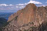
Photo: Mark Weber
® The author(s) and naclassics.com | ![]() Back to climb page
Back to climb page ![]() NAC Home page
NAC Home page
|
|
Elephant's Perch, Mountaineers' Route By: Gary Clark | Climbers: Gary & Lynn Clark |Trip Dates: June 21, 2001 |
|
Photo: Mark Weber |
® The author(s) and naclassics.com | |
|
We had this route on our list for the end of a road trip to the Canadian Rockies in 2001, but simply ran out of time and motivation. That was probably a good thing, because we learned since then trip that it is quite popular in August. Our concern on this date, the summer solstice, was not crowding, but whether the snow would be sufficiently melted to allow an ascent without all the necessary technical accoutrements for that medium. The route's name notwithstanding, we really weren't looking for a "mountaineering" experience, just a good dry piece of quality alpine rock. Thus our first question upon arriving at the Visitors' Center at Redfish Lake was about snow conditions. The rangers had no useful information. We filled out a wilderness permit and hiked the short distance back to the docks that sit directly in front of the Lodge on the shores of this, unquestionably the most beautiful major lake in Idaho. We had a bit of luck at that point. The lad renting tourist boats confirmed that we could take a shuttle at our convenience to the upper (south) end of the lake, thus saving over 4 miles of hiking. The tariff for this was $10 apiece, round trip. More importantly, he had climbed our intended route before, and had hiked to the base of the Perch a few weeks prior. He confirmed that there was still some snow, but one could "kick steps up it in running shoes." I told him we were thinking of crossing the lake early the next morning to do the climb and return in a day, but he indicated that would make for a very long day, so we decided instead to take a light tent and sleeping bags to the base, then get an early start on the route the next morning so we wouldn't have to worry about catching the last shuttle boat back across the lake. Laziness is a great motivator. Redfish Lake is the location of some of my earliest memories of mountain scenery. While I was a child growing up in the agricultural area further south in the state, our family often made weekend camping trips to the shores of this large, crystal clear, glacially-carved lake surrounded on all sides by the rugged, granitic Sawtooth Mountains. Later I was to water-ski on this lake, with the priority being to avoid taking any risks that might result in a fall into the nearly freezing water. It was the early 60s, and we weren't aware of wet suits. My first climbing experience had also started and ended at Redfish. With three former high school buddies, we carried our Boy Scout and army surplus camping gear to a tarn lake at the base of Thompson Peak, the highest in the Range. I had agreed to come along on this trip assuming we would be hiking up a nice big rounded hill from the top of which there would be a good view and hopefully some photographic opportunities. A rounded hill it was not, and we found ourselves in way over our experience levels (which for the four of us totaled to just about zero) as we struggled up a steep and wet couloir to the final ridge, and then the summit. Opportunities for photographs were everywhere, but I seriously questioned whether it was worth being that scared in order to take them. However, the story is a familiar one - several weeks after this climb, we had forgotten our fear sufficiently to attempt another peak, and soon I was hooked. Almost a decade later after I had enough experience, training, and equipment to call myself a climber, I was once again living in Idaho. I began hearing from other climbers of a hidden dome in the heart of the Sawtooths called the Elephant's Perch. The name was unusual enough to pique my interest, but the stories always emphasized that this was really serious climbing. 5.9 in the mountains in that era was considered attainable only by the likes of Fred Beckey, Layton Kor, and Royal Robbins. I mulled over my early experiences in this range, which resembles most closely a miniature version of the Sierras of California, as we were pushed across the lake by 115hp of outboard motor. Very soon we arrived at the southern end of the lake, at what is called the "Inlet Transfer Camp." We did not pause to explore the facilities there, but started right out on the trail that parallels the tumbling whitewater of Redfish Lake Creek. The trail was broad and well maintained, but we were able to enjoy this easy travel for only about an hour before we knew it was time to find the creek crossing that would take us up the drainage leading to the Perch, now visible in profile to our left. At first we went well past the crossing, then being sure it couldn't still be ahead of us, back-tracked to a likely looking spot. There were some spindly-looking logs across the turbulent stream, which was running at maximum spring flow. We negotiated these on hands and knees, since no individual log appeared strong enough to step on. Once across, I picked up a faint trail leading upstream for 50m or so, then cairns pointed up onto some granite slabs. The trail was just good enough and the cairns just frequent enough that we were able to stay with it for the next 45 minutes with careful attention. Then it got sticky. It seemed that the best trail headed directly up toward the face over steep slabs, but it was obvious there would be no camping up there, and we needed to find a water source for the night. Traversing further across a steep wooded slope on benches of granite, we came to a talus slope separating us from the creek, now nearly a waterfall coming from a notch well above us and to the south of the Perch. I reasoned that this creek must drain the lakes, but not knowing whether there would be camping there, we decided to leave our packs at a potential camping spot and explore unencumbered. This short reconnaissance ended 30 minutes later after we had traversed talus, a long snow slope, and finally narrow granite terraces to discover the most northerly of three lakes apparently called the Saddleback Lakes (not named on the USGS map). If it had been two weeks earlier we would have had to camp on snow, but now there were a few dry patches showing that would just take a tent. Now we had to retrace our steps and return with our packs - the second major time-wasting detour of the day. The lack of a guidebook for this area renders all climbs relatively adventurous. From the lake, it was apparent that the best approach to the route would be to climb up to terraces at the right side of the face, then traverse left across the major part of the wall. This turned out to be a routine, although not totally trivial hike. We were fairly certain we were at the base of the initial chimney pitch from the topo contributed to the NA Classics project by Idaho native Mark Weber. The key to finding the route is the huge diamond of flawless granite on the left side of the face. The Mountaineer's Route begins almost directly below this, later to bypass three quite obvious roofs, then up the left edge of the diamond itself to gain the cracks of the upper pitches. I started up the first pitch, finding it considerably easier than the advertised 5.6 rating until the very top, when it became obvious I needed to step out of the chimney to a crack on the left. The belay was marked by a 2-foot high "dunce's cap" of rock, around which there was a long sling from which some party had doubtless retreated. The next pitch was relatively unmemorable, and the key to the third was the small bush that signaled a traverse to the left. On our right was the major dihedral that descended from the big diamond, but little of the climbing was right in the dihedral. Instead, the face to it's left, which seemed so featureless and steep from below, presented small crack systems, shelves, and ramps that made the climbing quite reasonable, if exposed. Protection was quite good, although in my desire not to use any key pieces that might be needed high on the pitch, I often arrived at the next belay having placed only 3 or 4 pieces. The third pitch ended spectacularly on a foot ledge just below the imposing triple roofs. This was one of the most exposed sections of the climb, and one that cemented its classic status in our minds. Two modern bolts secure the belay, from which it seemed possible to either traverse left on good holds to the arête, or climb straight up to the lowest roof before traversing. I tried the lower traverse first, but was left contemplating a tricky move about 25 feet from the belay with no protection. I back-tracked and went with the straight-up alternative. The lower roof provides a sharp edge with a good crack behind it, which I liberally decorated with small cams as I did the short hand traverse out to the corner. Classic. At the corner, I was presented with a single crack soaring up an otherwise featureless wall, with gut-wrenching exposure. We agreed later that this was by far the best pitch of the climb, although all were quality. Through the penultimate pitch I found most of the climbing to be at around 5.6, with only the occasional move or two of 5.8, and we dispatched with each in around 30 minutes. Only on the final pitch was the route finding less than evident, and I wasted considerable time choosing the best crack system and avoiding the many loose flakes that marred an otherwise solid climb. Weaving back and forth and even down-climbing a short section when the key holds turned out to be killer loose blocks, I eventually strung together a combination of cracks that provided relatively easy climbing until the final few meters. Here the possibilities narrowed to a single crack through a roof that looked like it would merit the 5.9 rating of the pitch. This section was not greatly different than many below it except for the lack of footholds, and so I found myself committed to foot smears on a smooth vertical face, secured by good hand jams. With a good-sized rack, considerable rope drag from my wandering, and a sizeable pack on my back, this section was clearly the crux of the route, but it was only 15 feet long, and the protection was A1. Just above the roof I simultaneously ran out of rope and found a small ledge with a good crack for a belay anchor. The topo showed a third class gully to the top from here, so effectively the climb was in the bag. I hadn't realized that my route finding problems and slow deliberate climbing on this pitch had consumed almost an hour, and my partner was by now almost frozen in place at the stance below. Due to our early start, we had done the entire climb in shade, and though the day was sunny and warm down below, we were now above 9000', and even fairly complete alpine clothing hadn't been sufficient to keep her toasty. She paused frequently while cleaning the pitch to blow on her fingers, but still arrived at the belay with little feeling in them. I handed her the rack, saying "It's supposed to be 3rd class, which I don't believe, but it doesn't look more than 5.4, and it will take you into the sun." This was all the inducement she needed, and she soon ran the full rope out to the ridge where she could bask like a lizard. To my surprise, it was now obvious that we were a long way from the summit of the Elephant's Perch. The ridge we were on rose steeply and offered no obvious route. We had finished the route, though, so the actual summit was only a postscript. We unroped and began a traverse around the back side of the feature. As we did, large open slabs came into view which would have provided an easy scramble to the top, except that they were largely snow covered. Through careful route-finding we managed to avoid all but a few short sections of snow gullies which drain the back side. These would have been routine with an axe and crampons, but we had only sticky-rubber approach shoes and a sharp rock. After traversing all the way around, we were once again above the lake where we had camped. I was fairly sure the big gully to the immediate south of the Perch was the regular descent, but it was a bit of a gamble to start down it, since there were no footsteps after a long winter of snow cover and water erosion to indicate it was the right choice. At first the gully was actually pleasant and aesthetic, but soon it became a heavily eroded steep chute of unstable rock and dirt. We stayed close together to avoid rolling rocks on each other and made the best of it. My concern about coming to an impassible terrace was realized toward the bottom, but one of the trees I had noticed when examining the gully from below the night before turned out to have a mess of slings around it, complete with rap rings. Now to see if a single 50m rope would make it to the talus. . . hmmm, not quite, but the last bit could be down-climbed. Back at the tent we noted that we could possibly make the 5:00p boat down at the Inlet Camp if we really hustled, but what was the point? We were alone on the shores of a postcard alpine lake, in perfect temperature, with no wind. There was no hurry to get back to civilization; the 7:00p boat would be just fine.
|