Half Dome, Snake Dike
By: Gary Clark | Climbers: Gary & Lynn Clark |Trip Dates: September 12, 2002
Photo: Gary Clar
® The author(s) and naclassics.com | ![]() Back to climb page
Back to climb page ![]() NAC Home page
NAC Home page
|
|
Half Dome, Snake Dike By: Gary Clark | Climbers: Gary & Lynn Clark |Trip Dates: September 12, 2002 |
|
Photo: Gary Clar |
® The author(s) and naclassics.com | |
|
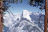
It had been a long time since we had been in the Valley; so long that neither of us could recall the last climb we did here. I had deliberately avoided this as a climbing destination since moving from the state almost two decades ago. There were very few climbing objectives left here for me that were so irresistible that I was willing to put up with the crowds, the traffic, and the bureaucracy of getting there and (particularly) staying there. However, there was one - the Snake Dike route on Half Dome was not only one of the most frequently nominated routes for the North American Classics collection, but it had been on my personal tick list since before I forsook the Sierras for the great American Southwest. Lynn had never been atop Half Dome by any route. We had been trying for the past several years to work this route into an itinerary. Finally we decided that our major road trip for the year should be devoted to the Sierras. In recent years we had usually reserved the month of August for Canada, but doing that marathon drive two years in a row had dimmed our enthusiasm, and the number of unfulfilled objectives in the Golden State finally became irresistible. We put together a list of "must-do" and "maybe-do" routes, concentrating mostly on alpine objectives on the east side of the range, but with Snake Dike near the top of the list. The opportunity to get around to the west side arose in an unexpected manner. After climbing for a few days in the southern part of the range, we drove up highway 395 to Tioga Pass, intending to pick off the highly recommended Third Pillar of Dana. Although the weather had been California-perfect up to that point in the trip, we found drizzle and a temperature of 42F at the pass. The climb was not even visible through the fog and rain. We decided it was time for a little R&R in civilization, and kept the pedal to the metal until we reached the Bay Area. A few days later, after visiting family and old friends, we were back on the road. I had reserved a campsite in the Valley via the Internet, a fortunate coincidence perhaps only possible due to the date - Sept. 11. We had no illusions as to the quality of the camping experience, however, and our expectations were amply fulfilled. Camping in the Valley is typified by a density of humanity usually associated with the hearts of major third world cities, and with commensurate air pollution levels. For some reason, normally rational humans arrive in this formerly natural environment and proceed to deliberately transform it into something almost unsupportive of life forms. Motorhome generators hum, car alarms go off, and hundreds of campfires smolder into the night. Air quality this bad would trigger a serious health alert in Los Angeles. Within minutes I was coughing, and my breathing apparatus would not clear until well up the trail the next morning. We knew it would be a big day, so we were on the trail well before first light the next morning. On the wrong trail, it turned out. The area around Happy Isles at the southeast end of the Valley is complex, and it had changed substantially since my last visit. We thrashed around in the dark for about 30 minutes until finding the only Merced River crossing (it's the road), then were finally under way up the steep trail past Vernal and Nevada Falls. At this time of year there was no mist on the Mist Trail, the section of trail named for the drenching you would get from Vernal Falls if you climbed it in spring. The Falls was barely a trickle. Higher, Nevada Falls seemed a little more impressive, but maybe only because it was becoming light at last. We reached a shelf where the trail finally flattened out and stopped for breakfast. Let's see - the SuperTopo guide indicated that we should continue hiking until the shoulder coming down from Liberty Cap dwindled to near nothing, then exit the main trail onto a climbers' trail. About 100 feet along the mail trail a climbers' trail, replete with cairns, started up the slope to our left. Hmmm . . . the steep part of the shoulder from Liberty Cap had dwindled, but there was still a long low-angled shoulder. We gambled and headed up. After climbing to the top of the shoulder, it was obvious this was a mistake. We now had to descend tricky slabs to reach Lost Lake, wasting energy and time. We should have interpreted the guide literally, bypassing the entire shoulder. Usually this wouldn't have bothered me, but we knew we had over 16 miles of travel with 6000 feet of climbing that day, and were now on our second diversion. From the point where we rejoined the correct approach trail at Lost Lake, the approach was complex, but well marked and logical with frequent cairns. We wound back and forth through brushy areas that had been recently burned, and eventually gained flatter ground on the shoulder well to the west of the huge South Face. If there had been any question about the location of the route, it was quickly dispelled. The slanting rays of the morning sun rendered a series of dikes in dramatic relief, like so many snakes crawling toward the summit. I could easily imagine the first ascent party here on their exploratory hike pointing up excitedly at these intriguing geologic features. To this point we had heard and seen nobody else, but then Lynn pointed upwards saying "There's another party." We arrived to find them almost ready to go, so we relaxed and got ready to take photos of their first lead. It started trivially on a smooth low-angled slab, but once the leader had a piece in under the sizeable roof at the top of the slab, the fun began. I was well aware of the 'R' rating of this route, which always gets my attention, even at the moderate 5.7 rating. However, this pitch didn't seem to rate it, because it was clear he could easily drop back down to the easy slab and complete most of the leftward traverse with a pretty good top rope, only risking a pendulum fall toward the end where the difficulty tapers off. 'PG' maybe, but not an 'R' on this pitch at least. Now came a long clean flake, which he climbed to the top with little protection to gain a pair of modern bolts for the belay. He was climbing quickly and efficiently, and any concerns I had about being stuck behind or climbing past beginners were dispelled. In fact, with the additional duties of drawing taking notes for a topo diagram and photography, we would not be able to stay up with them the rest of the day. The next pitch was the first to utilize one of the dikes we had come so far to experience. Heavily featured with knobs and mini-huecos, these typically 4" to 12" wide dikes intersect in a pattern that allows connecting them via short face sections for the next 4 or 5 pitches before the angle of the rock kicks back to the point that their presence is no longer critical and one can climb anywhere. Although heavily featured, they offer very few points for protection, the occasional slung chickenhead the exception. The climbing was moderate. Very moderate. Why, then, did I have that feeling in the pit of my stomach usually associated with leading near my limit? There is something unique about teetering up a narrow dike, even on excellent holds, where the rock to both sides is perfectly smooth, and the last bolt you clipped is 80 feet below. The old adage from the early years of the sport came to mind repeatedly: "The leader must not fall." Even when the angle backed off and climbing became 4th class, we kept the rope on and a piece of protection between us as we simul-climbed rock normally we'd have scrambled unroped. This much exposure can do strange things to your mind. Our new friends Rob and Georg had waited on top for us; a nice gesture and one we greatly appreciated since our conversation on the way down made the first few miles of the trail go faster. Before we could get to that trail, though, we had to negotiate THE CABLES. I had been up the cable route many times in the dim past. Very early in my climbing career before knowing any better I had actually scrambled the slabs just to the south, sans rope, in vibram-soled mountain boots. Now I was surprised to see how steep they seemed from above, and was completely taken aback when my stealth-rubber soled shoes began slipping frequently. A zillion tourist trips up and down these has polished the rock between the cables to something resembling the marble on a tombstone. I still had my harness on, and felt much better about the whole thing after I clipped into the cable with my daisy chain. Two daisies would have been ideal, so you could descend using the European "Via Ferratta" technique. I'd have wondered if I had been the only one in our party who had this reaction to the cables experience, but in fact all four of us now traveling together expressed amazement that the normally staid Park Service would continue to sponsor this arrangement for getting up and down the Park's most famous feature. "I can't believe there isn't a big pile of bones at the base of this" summed up our consensus opinion. Rob and Georg had sensibly camped at the backcountry campsite below the South Face the night before, so when we came to their trail junction, we said our goodbyes and gritted our teeth for the final toe-crunching section of trail back to the Valley and our car. There is little that can be said for this except that orthopedic surgeons would do well to advertise knee reconstructions along the way. |