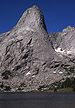
Pingora, Northeast Face
By: Larry Sverdrup | Climbers: Larry Sverdrup, Todd Cantor |Trip Dates: July 26, 2000
Photo: George Bell, Jr.
® The author(s) and naclassics.com | ![]() Back to climb page
Back to climb page ![]() NAC Home page
NAC Home page
|
|
Pingora, Northeast Face By: Larry Sverdrup | Climbers: Larry Sverdrup, Todd Cantor |Trip Dates: July 26, 2000 |
|
Photo: George Bell, Jr. |
® The author(s) and naclassics.com | |
|
On July 25th we slept in, recovering from our Wolf's Head adventure. After brunch we packed up and headed for Pingora. The hour was late, but we were pretty confident in our ability to move fast on the rock as our acclimation to the altitude had only improved. We were camped near the exit to the basin, and Pingora lay on the far side of Lonesome Lake. At the start of the route, Todd did some dicey traverses across exposed slabs to reach the rope up spot. I took the more mundane and safer approach staying wide right. At the rope up spot Todd discovered that he had neglected to pack his climbing shoes. By the time he ran back to get them, precious time would be lost. In addition, he feared aggravating his knee running back to camp. We decided to come back for the route early tomorrow. Unfortunately, the weather this day would be the best it ever got while we were visiting the 'Winds.' Descending, we ran into Bill and Dave from Connecticut who were also planning to do the route tomorrow. Yet another group arrived to scope things out for tomorrow. Both the 50-classics description and the Winds guide state that two 150-foot ropes are necessary for the descent. We found out from the other group, who had climbed the South Buttress of Pingora the previous day, that two ropes are no longer necessary. Intermediate rap stations exist. This meant that we could leave our second rope behind. As we parted and headed back for camp, Bill joked that "It was a great day for climbing," since we were obviously squandering a perfect day to do the route. Many people visit Lonesome Lake basin, and it is hard to avoid hiking on the grass. Everything is green and full of wild flowers. It didn't seem like there was an excess of human trails. It was as if the vegetative life force in this place was stronger than the force of human foot traffic. On July 26th, we arose well before sunrise and soon a group of deer jumped through the small meadow below our camp. By now we were well acclimatized to the altitude. After a hot drink, we hiked back to Pingora. An unknown pair of climbers was starting the route when we arrived. Dave and Bill arrived as we geared up, and yet another unknown party arrived behind them. The weather seemed different today and I mentioned it to everybody. There were cirrus clouds the previous two days, and now it was almost too clear. The guidebook says that precipitation occurs more than half the days in the summer. It was about 7am when we started climbing. Todd took the first lead, some friction traversing over to the start of the dihedral. Near the end of this traverse he made a direct finish, probably climbing at least 10a to do so. Not liking the fall potential after I removed his pro, I back tracked and frictioned down to a lower ramp which then trivially led back to the dihedral. The climbing pair in front of us moved fast and was never an obstacle. I led the dihedral, and the climbing seemed a little stiffer than I anticipated. Pro had to be conserved, as the pitch was quite long. Anything short of a 200-foot rope and the number of pitches necessary would probably increase. As it was, the route topo said there were 11 pitches. (We ended up doing it in 13.) We climbed with one pack only, carried by the follower. It became clear that it was far preferable to lead without the pack, rather than to follow with what felt like a 20-pound lead weight on one's back, climbing at 11,500 feet. There were no trivial pitches, but rather a uniform level of difficulty the entire way. As we traded leads, cloud activity arose. The clouds alternated between building and dissipating. Wind seemed to blow the clouds past us before they could build significantly. Several pitches later we were in the famous "grass hummocks" pitch, featuring tiny ledges made of dirt, held together by vegetation. After (or perhaps near the end of) the grass hummocks pitch, the route topo suggests that one should veer right up some ledges. Dave and Bill had heard from another party who had done the route that this was a time wasting detour and that one really wanted to go straight up. One can see the flaring chimney and the 5.9 layback alternative above from this branching point, and going straight up is indeed more direct. Todd and I went to the right and Dave and Bill went straight up. We both arrived at the flaring chimney, proving that both ways go. We maintained our lead during this episode. There was no mistaking the mackerel sky, and I related to Bill the adage, "Mackerel sky, storm is nigh." Weather was coming; it was just a matter of when. The route on Pingora is so long, that if one doesn't climb fast, one needs a full day of good weather. Someone later told us that as a rule, it is good to summit before 2pm to avoid afternoon thundershowers in the Winds. I led the "crux" flaring chimney, which was significant but easier than it appeared, placing a #4 camalot near the end as the guidebook suggested. It seemed to me that the #4 was not absolutely necessary. On the other hand, we used the #4 in numerous locations on the route, so bringing it was not at all a waste. Three and a half more pitches and only the final "5.6" pitch remained. At this point one could bail onto and down climb 'Bonney's Route' (5.2) in bad weather. Since this descended the South Face rather than the South Buttress it might be safer in an electrical storm. After a few photos I charged up the final pitch. It was not a short pitch as it appeared, and there were some moves required. Midway a short off-width crack provided a challenge. When possible lightning is approaching, I am not one to dawdle. We both thought that the climbing on this entire route was of very high quality. As I belayed Todd up to the top, a cloud looking ominously like the anvil of a thunderhead crept overhead. We jogged up to the "false" summit and it was clear that the mountains to the north of us were being pounded by rain and it was moving in our direction. It was approximately 2pm. The South Buttress rappels are the fastest way off of Pingora. We rapped down the canyon separating the climbing route from the true summit. At this point we were actually on 'Bonney's Route' and could begin descending the South Face if necessary. Instead we traversed over to the first rappel down the South Buttress. This traverse is mildly exposed at one point, but bombproof handholds are available. From here one could scamper up to the true summit, but neither Todd nor myself felt the need to do that with weather moving in. I figured that were I to gloat over my 25th 50-classic climb on the summit of Pingora just then, I would be smitten by a thunderbolt from heaven. A group of four Oregonian Mountaineers had their ropes in the rings. We asked them if they were going to pull them so we could set up. They gladly offered the use of their lines to us. We rapped down to a ledge joining them, where in addition another pair of climbers was in the process of deciding whether to finish their climb up the south buttress, or bail due to weather. They wondered if the storm would miss us to the North. The first salvos of thunder reached us from the approaching storm and these two climbers smartly decided to bail. Two climbers could be seen on the summit of Wolf's Head, not an enviable position. Two more long raps brought us even with the top of the lower SouthBbuttress. The raps went smoothly albeit slowly, but the storm was moving in slowly as well. I noted the intermediate rap stations, but we did not need to use them as we had the use of the doubled ropes of the Oregonians. From the end of the final rap, one hikes a short, mildly exposed traverse south to get on top of the lower south buttress. From that vantage we could see that there were many climbers scattered over the south buttress climbing routes. On the northeast face we saw no climbers other than those on our route. An unknown climber pointed us in the right direction. One hikes south down the top of the buttress until a cairn is reached near the west side of the buttress (e.g. toward Cirque Lake). At this point one drops down the west flank of the buttress and doubles back to the north following an obvious short ramp system to the ground. Back at camp we watched as lightning bolts struck beyond Lonesome Lake basin near Pingora, but to our knowledge, none hit it. We packed up and took the climbers trail back. This trail avoids the larger elevation gains of the Jackass Pass trail and is safer in an electrical storm. Near the pass, Todd photographed a grazing deer. The climbers trail passes below the dramatic Warbonnet Peak and above spectacular Arrowhead Lake. Stay near the top of the boulder field and follow the cairns. A couple who took a route along the lakeshore warned us of the route finding difficulties encountered traveling amongst huge boulders. Near the end of the boulder field toward Big Sandy Lake a few boulder moves were required. We ran out of insect repellent on the hike out. Although the weather seemed to clear somewhat at the beginning of our hike, later on we were exposed to a constant barrage of thunder as a second wave moved in. Luckily, most of this weather missed the dirt roads out of the Winds, and we escaped in our 4WD without incident. Editor's Note: The author is a Major Contributor to the North American Classics project. |