"Sorry guys, I gotta go." I left the meeting half way
through - mid topic. "I really have to take care of this."
And so began my trip to the summit of Mount Slesse via the classic Northeast
Buttress route. It was Friday at noon in Whistler, B.C. and, well, it
was time to go. I joined John at his truck in Squamish, and we arrived
at Subway in Chilliwack 2 hours later- not 2 minutes ahead of Matt and
Mark. Matt had an excited grin on his face as he entered the restaurant.
Mark sorted gear eagerly and without haste behind his SUV. Yes, it was
finally time.
Mark and I started talking about Slesse almost from the time we started
to consider climbing technical mountains - maybe five years ago. We had
loosely thrown around dates in the past, but hadn't gotten it together.
Exactly two years ago to the weekend, we had gazed at it in awe from the
top of Mount Rexford, across the Nesaquatch drainage to the north. Now
we were here. We wolfed down a sandwich and began the truck drop-off/shuttle
that would leave us transportation at the descent trail's end. The four
of us piled into Mark's truck and headed for the approach.
The trailhead was easy to find, marked by a signpost with a foil pie
plate tacked neatly to it's top. It was 6:00 PM and we were right on schedule.
We hurried up the immaculate trail, neatly groomed by the good ol' boys
at the nearby Ford Correctional Institute. "Man, we gotta tell
these guys about the other peaks we wanna climb in this area,"
chuckled John- a young offender's community service advisor himself. "This
is the kind of good work I like!" Coast Mountain approaches,
in our experience, had run the gamut from vertical bushwhacks to slide
alder crawls and endless battles with nasty Devil's Club and Stinging
Nettles. This was a cakewalk.
After one hour of neatly groomed and graded logging skid, we arrived at
the Slesse Memorial Plaque, a reminder of those killed in a tragic plane
crash that killed all of it's passengers when it slammed into the East
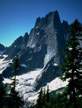
Face of Mt. Slesse in 1953. A sobering sight it was; the menacing north
and east faces of Mt. Slesse framing the intimidating N.E. Buttress route,
it's peak shroud in a swirl of thin cloud. This was a great adventure,
and we were buzzing with anticipation. We snapped photos, quenched our
thirst, and continued on our journey.
Mount Slesse isn't just any climb. Not that it's super technical or a
historic first ascent, but it does offer a dramatic line up a flying buttress
that's as beautiful and sheer as it is unique. Once you have seen its
incredible profile in a photo, or gazed at it from nearby peaks, you just
have to climb it. If it's half as exciting to be on as it is to look at,
then it must be incredible. And the best thing is that the climbing is
25 pitches of nothing more than a couple moves of 5.9, with lots of 5.7,
and a good 3 pitches of solid 5.8; attainable for the weekend warrior,
committing, and close to home!
By 8:30 PM we had reached a perfect sub-alpine bivy, one hundred meters
from the trail's end and conveniently marked with a propeller pulled from
the airplane wreckage. Two Americans had a camp at the trail's end and
waited for two more partners to join them. We said "Hello",
and swiftly settled in below and out of sight. We burned an evening fire
in the existing pit, and plotted strategy for the next morning. Our goal
was to climb our objective in one day, and be in the pub on Vedder Road
on Saturday night. If every thing went our way - energy, route finding,
the condition of the pocket glacier, and no traffic en route - we would
just make it. We had packed extra light in order to accomplish this goal.
The bivy tonight would be in down jackets (except for John in fleece only),
with one bivy bag and two emergency blankets between us. Meager scraps
of weathered ensolite pads also appeared out of packs- a bit of a joke
really, but what the hell - potential first aid material if needed! Our
goal was to leave at first light, ahead of the Americans.
The night ahead would be a chilly affair. As our fire faded, so did
the day's warmth. Mark, John, and I huddled together under our remaining
reflective blanket. (John's excuse for a blanket was a twenty-year-old
foil sheet, ruined by a run-in with a leaky Muskol bottle years ago and
useless). Matt settled into his bivy bag, and we huddled in to watch the
moon rise behind the South Peak's East Ridge. This created a brilliant
halo of light behind a jagged gendarme, and illuminated the rising mist
that still engulfed Mt. Slesse. As if this wasn't enough it was also followed
on cue by a brilliant green display of Aurora Borealis, and a spectacular
meteor shower that went on throughout the night. Rocks and ice rattled
down the adjacent East Face and the crisp bite of almost freezing air
kept us wide-awake. If nothing else, we were pleased to be up for the
visual spectacular. We all rolled over in-sync throughout the night trying
to keep each other warm. John and Mark clung tightly to their edge of
the blanket, while I enjoyed my good fortune in the slightly warmer middle
position.
Morning came slowly as we waited with anticipation for dawn to break.
We wrestled briefly with a last ditch fire effort and brushed the frost
from our packs, when a faint orange glow behind nearby William's Peak
gave the signal to go just after 5 am. We skipped off across the East
Face slabs with the Americans close on our heels, aiming for the notch
that serves as the entrance to the objective basin, and the doorstep to
the N.E. Buttress.
The slabs were polished and smooth from year after year of snowfall turning
to ice and sliding into the valley below. We filled up with meltwater
and moved quickly across to the notch. Orange light now illuminated the
summit as we gazed across at the unexpectedly large and serac-ridden glacier
barring passage to the buttress. My first reaction? Don't go. All that
planning and don't go? I was racked with conflicting emotions.
"This way!" proclaimed John, tracing a route with his
hand through the iced suncups and mangled seracs. I looked down with doubt
at my Five Tennies. "Grab your chock pick, let's go!"
John stepped gingerly and quickly across the first stretch of snow with
mighty pick in hand. He paused briefly at the deep moat between him and
the lower slabs of the East Buttress and hurled his right calf over the
bergshrund's edge and declared, "On belay!" I nervously
began to cross, pick firmly in hand, and driven deep into the snow with
every other step. "This could be a long day," I thought
aloud.
Moments later we were across the snow, with Mark and Matt closely behind,
pondering our next move. The snow was way to hard and icy, we reasoned,
and the slabs would be our only option. We would have to skirt the top
of the pocket glacier along these slabs, and at some point make a mad
dash across a treacherous looking glacier or continue our traverse across
the impossible looking steep slabs above. Either option led to the grassy
4th class ledges that were the beginning of the buttress' first bypass
option. The hazard of icefall seemed too great to start at the buttress's
toe (which began directly across from our current position, fully exposed
to the unpredictable mass of ice). We began to simul-climb across the
slab, but not for long. Fine sand coated the polished slabs between the
intermittent ledges and meager protection, and we were forced to belay.
"No longer likely in a day," I sighed. The four Americans slid
by with boots and ice axes on the icy surface below, making good time.
Four roped pitches later we ran out of cracks and ledges and found ourselves
standing on the now softening surface of the glacier. With few other options,
John coiled 15 meters of rope around his neck and started across the broken
and icy snowfield. The sun would only speed the collapse of the giant
blocks that would soon surround us. We dashed madly through the mangled
maze to be greeted by the rock of the N.E. Buttress, and the bewildered
Americans. "Wow, you guys ran through there! We just took an hour
to cross that!"
"Well," I gasped, short on breath, "I guess
you weren't as scared as we were." John stripped off his pack,
and we enjoyed some much-needed relaxation. We would wait and watch the
progress of our unlucky friends Mark and Matt, who still had to cross
through the labyrinth of ice. Soon enough, they were through the icy hazard
and we were back on track. John and I were now finished the initial easy
ledge pitches, and on our way up to the buttress proper. It had been a
long affair, three hours for what was supposed to be only one. Our single
day ascent didn't look likely.
The rock steepened to fifth class and we proceeded with roped pitches
to the second buttress bypass - a shaded north facing alternative with
climbing to 5.7 and a great view down the north face. The climbing here
was pretty good, with mostly solid rock, and pitches that seemed to do
what Beckey's topo said they would. We moved quickly with no parties visible
below, and a new party above. We had heard them earlier, but had thought
we heard the Americans below. When we caught sight of them briefly, they
were climbing through the buttress direct crux at 5.10. Our route bypassed
these pitches, opting for a 5.9 crux higher on the route and, we reasoned
a better shot at a one-day journey. We continued at a good pace and regained
the buttress at a steep flake corner that would give us our first sustained
climbing of the day. This first 5.8 pitch looked great, with solid pro
and a nice line. We climbed it comfortably, and popped up onto the huge
bivy ledge that signals the halfway point to the summit. Our new friends
were relaxed and melting water. Their goal was to finish the route and
bivy near the peak. It was 1:30 and they would have just enough time.
Heavily loaded with gear, they had already spent their second night out,
and were prepared for a third on the chilly summit.
And now our dilemma. We had climbed 14 pitches, some merely scrambles,
in about 5 hours. Nine more loomed above, with sustained climbing in the
5.7 to 5.9 range. This would slow our pace, as would having another party
ahead of us. In addition, our partners were still an undetermined distance
below, and the thought of a bivy higher on the mountain didn't appeal
to either of us. The ledge would be comfortable with 8 people on it. It
was huge, and the sun was just coming out from behind the peak. The prospect
of a relaxing afternoon of sunshine on this grassy exposed perch wasn't
that bad. It was much better than hurried climbing to an undetermined
bivy in a colder and no doubt more exposed environment. This coupled with
the uncertainty of how Mark and Matt were progressing sealed it. We spread
gear all over the 500 sq.ft. of the pie shaped bivy to dry, and enjoyed
a smoke. John placed his Nalgene under the drip of a dolphin-sized block
of snow on the ledge, and we watched as the party ahead traced the route
up the buttress. They had climbed most of yesterday in a blanket of swirling
cloud and this afternoon would be no exception. After five pitches they
were engulfed again, and we were glad we had stayed, still in sunshine
and half-asleep in more comfort than we imagined possible.
At about 3:30 PM the others started to arrive. First it was Kyle and
Paul, then Eric and Nick. Finally Mark and Matt appeared around 4-4:30.
Matt shook his head, "Thanks for waiting guys. We were all over
the place." Each of them had led pitches well off of the route.
Mark's foray took him up a dead end crack that ended in horribly steep
and unprotectable face climbing. After briefly considering a leap onto
the sloping ledge 8 feet below, reality sunk in, and Mark waited 20 minutes
for the passing party of Paul and Kyle to grab a bight of his rope and
clip it in above. Mark did a pendulum off of his lofty perch back onto
climbable terrain. All of the conditions we were expecting to avoid to
successfully do Slesse in a day had prevented it from happening; a treacherous
glacier, poor route finding, and other parties on route had all played
a role in our fate. It just wasn't meant to be. This bivy, however, was
as good as it gets.
The eight of us milled about taking pictures, gathering water, eating,
leveling bivy sites, and swapping beta on our respective routes. Our American
friends coughed up food, water and extra layers to supplement the optimistically
light loads of Matt and Mark. We studied tomorrow's line and settled in
for another long, cold bivy. This time we huddled in groups of two on
tighter bivys in order to more efficiently share heat. It seemed to be
perfectly effective until shortly after midnight when the mercury tumbled
and a chilly breeze swept away precious body heat. John and I caught only
the briefest glimpses of sleep, but perfected our well-practiced, in sync
roll over. John hung on to the edge of the tarp with his teeth to prevent
it being blown up by the breeze. Morning couldn't come too soon.
When first light did hit, we were up and ready, determined again to lead
out ahead of our new friends. John uncoiled ropes and leapt onto the opening
moves before I could even tend to a belay. Matt and Mark were hot on our
heels and we moved into the meat of the climbing high on the N.E. Buttress.
The climbing above was both sustained and exposed, in an awesome position
very close to the crest of the buttress. It alternated from solid and
steep, to slightly less technical with sections of loose flakes and blocks.
At one point I even ripped a small handhold off one of the more solid
faces while seconding a steep 5.8 section. We weaved through two blocky,
uncertain roofs in spectacular positions looking steeply down both north
and east faces. No pitch seemed any less challenging or enjoyable than
the others and we moved efficiently on our way to the jagged summit at
12:30 PM. Arriving an hour ahead of the others, we again settled in to
enjoy lunch with on and off glimpses of sunshine. Views in all directions
were nothing less than spectacular with views of Mt. Baker, the Border
Peaks, Shuksan, and the Fraser Valley. Matt and Mark arrived, we snapped
summit pictures, snacked, packed racks, and began the south side descent.
The descent trail was easy to find, and wound its way around an exposed
corner to the obvious first rappel. We rapped quickly onto the broad and
gentle gully between the main summit and two sharp, spectacular gendarmes,
then moved down and to our right to a point where the gully steepened
significantly. Looking for the obvious ledges that were supposed to take
us across the face to the next gully, John made the first rappel into
the blind gully below. The rest of us waited, cautiously uncertain of
the way down.
"Go back up!" a distant female voice called up. Then
silence. We looked far below towards a tiny yellow tent 3000 feet below.
"Hey John?"
"Yeah, yeah, put me on belay."
We looked across at the solid face beside us. It certainly wasn't obvious.
Nor was it marked in any way. John moved quickly back up, across and around
the corner. "This is it, man." Phew. That was lucky;
the gully below was long, steep, and exposed to rockfall the whole way.
Matt and I gathered stones and built a cairn to mark the traverse for
the American party. Misty clouds swirled around us for 10 minutes and
then broke above and below us. The sun warmed us as we looked down for
the distant tent where our timely messenger had signaled us. Hmmm-m-m-
no sign of her or the tent. It would make a great story- the guardian
angel that appeared at exactly the right time, and then magically disappeared
into the mist.
We continued across a grassy bench to the next belay down a clean slabby
gully. We scrambled right again through mellow terrain and rappelled again
into a rocky gully below, the top of the Slesse Mountain Trail. The trail
snaked across grass and talus to a tree-covered ridge, and over the other
side. John followed it down long enough to realize we were off route again
and on our way to more uncertain rappels. We scrambled back up to find
the trail passing through a tight clump of stunted trees, and moving directly
down the ridge top. Half an hour later we were at the site of our guardian
angel. We gained, and again lost the trail at this camp. The trail here
went in multiple directions. John finally located flagging tape and the
well-worn trail that turned 90 degrees to the south on top of the flat
grassy bench. The trail dropped steeply for 5000' vertical feet to Slesse
Creek far below.
We caught up to the couple that had called to us back on the second
rappel. They had waited to break camp until we had passed through the
uncertain part of the descent. We thanked them for helping us avoid another
long cold bivy, and invited them to join us at the pub for a beer. The
Americans caught up to us shortly thereafter, and we invited them to join
us also. They declined. It was 8 PM, and they had a long trip home. We
pulled up our chairs to a couple cold jugs of pale ale, and wolfed down
nachos and cheeseburgers. "To Mount Slesse!"
And so concluded our long awaited ascent of the North East Buttress of
Mount Slesse. Let me tell you, it was a fantastic climb. We had great
fun despite long, cold nights. The rock climbing, and awesome position
was well worth it. The route certainly deserves its reputation as a challenging,
committing classic of the Cascade Mountains. Put it on your list!
Suggestions:
When parking your car on the Slesse Creek side, follow the road all
the way up on the East Side. Do not cross the bridge as Beckey suggests.
Continue on what is marked as "New Slesse Trail". You
will emerge right at your vehicle at the descent trail's conclusion.
If following the topo map for roads take the second possible road to get
into the Slesse Creek drainage, and turn up to Nesaquatch Creek at the
second possible entrance also, well past Ford Mountain Corrections Institute.
When you finally get on the obvious approach trail, stick with it. Don't
worry too much about shortcuts or other landmarks described in the guide.
The trail will spit you out on the south side of the East Face. Here you
can bivy (approx. 5500 ft.), and then cross slabs to an obvious notch
that leads to the infamous pocket glacier. Here is a fairly steep, short
descent to the slabs below. You can see the obvious toe, as well as the
easily recognized bypass option above. (Alternatively, head straight for
the buttress at the Memorial Plaque for a direct line to the buttress
toe. You will be exposed to the whim of the glaciers on this approach,
but will also get to the route faster if you are going for a one-day ascent
from the car.)
Once on the route, Beckey's guide is pretty good. Just follow the gist
of it, as opposed to looking for the lower pitches on the topo. Follow
your nose and cross over the buttress crest where it seems to go that
way. From here follow the direct or bypass routes depending on your ability,
and how you feel. Both are good climbing! If you do take the bypass, it
follows pretty obvious weaknesses to the right. Don't get sucked into
direct lines, once on the bypass, unless you want to make it much harder.
If you want sustained pitches climb the buttress direct!
The bypass route curves back left and puts you back on the buttress
in a great position. The obvious, steep, right facing corner will lead
you up to just below the huge bivy ledge. Stay on the ledge for a bivy
unless you still have lots of time. It's great accommodation, and a great
place to chill out! The route above is pretty obvious and follows the
guidebook's description pretty closely.
The descent is pretty easy to follow except that the traverse out of
the gully wasn't obvious to us. Look for a small cairn if it's still there,
and remember that if the gully below you is dropping out of sight then
this is the place! There is no obvious ledge, and you will probably want
a rope fore the first few moves. It is exposed and a little tricky. All
rappels that are on route have a number of slings and a rap ring of some
kind. If you are following a line of single slings, you are probably in
for a long off-route descent! If you keep your eyes open you will see
the trail well below to your right as you descend the route (also visible
from the summit ridge). The general rule as you descend is to keep high
and right until you are out of the weeds and on the trail.
Once on the trail look for the ridge ahead (beyond the talus) and don't
follow the trail beyond the ridge. The trail follows the ridge top directly
down, and then left of the ridge to a grassy flat plateau. The trail will
take a sharp left here. If you find yourself in steep talus slopes below
the plateau with a disappearing trail, go back up. Lots of markers and
tape flag the obvious trail down to an old logging road that will take
you directly to your vehicle. An off trail bushwhack would be long and
treacherous.
If you want to do the route with one bivy, you will want to be on the
trail as early as possible. The trail will be easy to follow in the dark,
and you should have no trouble reaching the main bivy ledge in one day.
Allow 3 1/2 hours to get to the routes first pitches for either start
(unless you thrash direct from the Memorial). The glacier could complicate
any approach, and it took us 2 1/2 hours to our bivy and 3 hours to slab
climb and run scared through the broken ice we encountered. (It appears
that the pocket glacier is going to last this entire season, and unless
we get a mild winter with a long summer after, it could be a long while
before the whole thing kicks off.) 5 hours should be lots to climb to
the bivy ledge, and another 6 to the summit. Obviously, times will vary.
No great bivys show up above the main ledge, but some good ones exist
on either side of the summit. (Small adequate ledges exist all over the
route if needed.) The descent is long and probably best when you can see!
Allow 5 hours. Have fun!
|