Editor's note: This climb is listed as the "South Face"
in many references. However, the face clearly points to the Southwest.
From the start, Mark and I had this crazy travel scheme for how we were
going to get there. We were each going to fly to Vancouver, then take
a small plane to the 'middle of nowhere' - Anahim Lake, where Bobby was
supposed to drive up to in his Volvo and drive us to Tatla Lake where
we would helicopter into the mountains. Well right off the bat, Mark and
I both forgot our birth certificates, so we were sweatin' it quite a bit.
I mean it's CANADA! You don't need a birth certificate for that right?
Well anyway they kept asking us at the airport and then at customs, so
I was pretty worried, but then I pulled out the ole' military ID and they
let me into their country. I was still a bit nervous about getting into
the states, but I figured I'd be good.
Mark and I met up in the Vancouver airport as planned and we hopped aboard
a shuttle to this other "airline" which was going to fly us
North. Well after taking the complete tour of the Vancouver airport (really
nice) we began to realize why the airline had warned to allow plenty of
time to get to their "terminal." We were now worried that we
would miss the next flight. We made it to the terminal about 30 minutes
before scheduled departure and figured we were good.
Then we were presented with the next crux. This small plane only allows
75lbs per passenger of luggage. We knew about this ahead of time, but
also knew we would be close. I was pretty sure I was 5 pounds over and
so was Mark. I was ready to throw one of my 10lbs ropes in the trash if
I had to, though. The girl weighed my bags and they were 77, so she said
she'd weigh Mark's and if they were under we'd be all right. Mark strategically
placed his bag on the scale in such a way that it was sitting on top of
mine (which was on the floor). His bag ended up reading 50-something and
we were good to go.
As we were boarding the plane we saw a young gentlemen whom we assumed
was a baggage handler and asked him which side of the plane we should
sit on to see the coast mountains. We were a bit shocked when we discovered
this was our co-pilot, as I'm sure he was younger than I was. The flight
went pretty well and we got awesome views of Mt. Waddington as we flew
by, probably 30-40 miles to the east. It was obviously the monarch of
the coast range sticking well above the other peaks. As we came in to
land the plane was swaying and shaking all over the place, which made
for an interesting approach. We were pretty sure we would have to use
the emergency exits to get off the plane, when suddenly, right before
touch down, the plane smoothed out and gently landed. The airstrip was
a decrepit old runway with a simple barb-wired fence to keep the moose
out of the way. The plane taxied up to the gravel parking lot where the
pilots jumped off and began to unload our luggage. Then we were faced
with the final crux in our voyage - Bobby making it up to Anahim Lake
in his Volvo. Sure enough, he was there and he had all the food ready
to go for our trip. We drove south towards Tatla Lake sharing stories
of our travels.
After a little bit of excitement finding the place, we located the chopper
pilot, Mike King, and hopped on board. The ride to the glacier was spectacular
and uneventful. We flew by numerous unclimbed and unnamed peaks and hundreds
of miles of roadless wilderness - probably the wildest area in North America.
As we flew around the massive flanks of the notorious Mt Combatant, the
North Slope of Waddington emerged behind. Its craggy summit looked challenging
and we were excited. We had to fly around to the south side to get to
the route we wanted to do (the Southwest Face) and when we turned the
corner, the entire south side of the mountain was socked in with clouds.
Mike the pilot, was able to drop us at only 7,000 feet. We would have
to hike the rest of the way. So much for traveling in lazy luxury!
We landed on the Dais Glacier at about 5:00pm, hurriedly sorted our
gear, and prepared to hike up to a high camp. We had planned on being
dropped at 10,500', the base of the Southwest Face, so that we wouldn't
have to hike anywhere, but it wasn't in the cards. We left basecamp by
7:00 and headed into the clouds, unsure of where we really need to go
since the summit and entire Southwest Face were obscured.
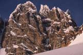
By about 9:00 it began to clear and we got our first glimpse of the
massive steep Southwest Face of Mt. Waddington. The near vertical 3,000'
high rock escarpment stretches over a mile wide, with craggy summits along
the ridge top. The actual summit tower, where our route lay, was the farthest
away from us. In our clouded judgement we had chose the WPR (worst possible
route) up the glacier to the base of the climb. Oops! Fortunately we would
be able to get to the base; it would just take much longer than expected.
After post-holing for five hours (Bobby and I didn't bring snowshoes,
we were supposed to be dropped at 10,000 feet!) we reached our high camp
at midnight and crawled in our sleeping bags. After making dinner we attempted
to get some sleep at about 1:00 and dreaded our early morning wake up.
We wanted to start at 3 or 4 in the morning, but ended up waking at about
6:00. We were on the trail at 7:00 even though we probably should have
just given up with a start that late. We didn't get much sleep and were
still tired from the long approach the previous night.
We climbed in earnest up the snow couloir notorious for rock fall. The
rock fall actually wasn't bad at all, but there was a constant flow of
powder snow down the gully which had even carved it's own channel in the
snow. By 10am we reached the beginning of the scary "snow traverse"
where the couloir runs out and progress is made by traversing along a
narrow, sloping, snow-covered ledge sitting about 1000 feet up a sheer
rock wall. The angle is probably between 70 and 85 degrees and the snow
somehow clings to the "ledge". Mark volunteered to lead this
section, and as he reluctantly ventured out onto it, he discovered that
it was easier than it looked. It was possible to climb on the various
rocks that poke out from the snow, and he was also able to find decent
protection. Nevertheless this snow traverse took three hours for all of
us to get through.
We all reached the top of the "triangular snowfield" at 1:00pm
and we were freezing our arses off. The next obstacle presented itself
and it was my turn to lead. The route calls for exiting the triangular
snowfield by climbing the left of two rock chimneys at its left margin.
We didn't find any rock chimneys, only two ice-filled gullies. The ice
turned out to be exquisite and my picks sank in with every throw. I placed
two ice screws on the 80-foot pitch, more for show than anything, as I
felt totally secure in the plastic ice.
Above the ice we had another snow gully before some mixed rock and ice.
I had to climb the rock with crampons on and gloved hands. This ended
up freaking me out and psychologically ended the climb for me. The rock
was probably 5.6 or 5.7 but it was too cold to climb bare handed, and
I couldn't get any decent protection. Eventually I made it to the snow
where I thought I would be safe, but to my horror, the snow was only a
few inches deep and hid rock underneath. I gingerly climbed upward until
I was able to find a crappy stance with two TCU's placed behind the same
loose-looking block about the size of a football. I called for Mark and
Bobby to follow and made sure they knew not to fall.
Bobby and Mark had much less trouble with the pitch and were ready to
continue on. By now it was already 3:30 and I couldn't believe we were
still going up! I knew that if I said anything we would turn around, so
I kept my mouth shut. I hoped we'd be able to find a spot to build a snow
cave to spend the night in, but so far we hadn't found deep enough snow.
We had heard that the second ascent team had bivied in a spot right above
us, so we figured they must have built a cave up there. Mark decided to
take over the leading and headed up a snow slope to the next rock pitch.
About 20 feet up the next rock section Mark down to Bobby and me:
"How much are you guys into this right now?"
I answered:
"Not at all. Let's get out of here and come back and do it Wednesday
or Thursday!"
"Right on!" was the reply and at about 5:00 we began
to descend from about 500' below the summit. We were able to reach the
triangular snowfield with two rappels, then had to reverse the scary snow
traverse. We did a lot better the second time; it only took us two hours
to reverse. We eventually reached our camp at 10:00 and crawled in our
sacks for an exposed, hungry night's sleep. The next morning (Tuesday)
we arose late and headed down to basecamp, a tent, and food! We had slept
too long and by now the glacier was slushy so it made for a laborious
descent. We reached camp three hours later and crashed in the tent to
kippered snacks and Ritz crackers.
Shortly after our initial failure we were already discussing how easy
the climb was and how it really wasn't that scary. It's amazing how soon
we forget! We made plans for our next attempt on Thursday...
Wednesday morning we arose at 6:00 to hit the glacier while it was still
frozen. Armed with the tent and three day's food, we headed for high camp
again. This time we knew the shortest trail and with the confidence of
cold temperatures holding the seracs in place, we were able to weave a
path through the crevasses and seracs. We booked and made it up 3,500'
in a blistering 2 hours. For the rest of the day we relaxed, ate well,
read books, played cards and did almost anything to keep our minds off
of what lay ahead of us tomorrow. Bobby decided that he wasn't much into
making another attempt and thought he was just slowing us down, so he
wouldn't be coming with us. Later we learned that it was actually the
climb through the crevasses and seracs that had freaked him out. He had
never seen anything like that before and decided he was in a little over
his head. It was understandable. The first time I saw a glacier like that
I almost threw up, and I sure as hell didn't set foot on it. It takes
a while to get used to that, and he wasn't as conditioned as Mark and
me.
Thursday morning we arose at 3am and donned our light gear. Based on our
previous attempt we decided to wear more warm clothes and bring more pitons
for the rock, as we found it almost impossible to protect the first time.
Nevertheless, we were still travelling extremely light. We were tied into
an 8.4mm x 60m rope that we would simul-climb on and we carried an additional
7mm x 230' line to rap with. For gear we carried a measly set of stoppers,
#1 and #2 TCU's, doubles of the Camalot Juniors, a #1 and #2 Camalot,
3 ice screws and a handful of pitons. Hopefully it would be enough for
the nearly 3,000 feet of rock and ice that lay ahead.
We left the tent around 4am and we were cruising. We climbed much faster,
deciding to simul-climb through the scary snow traverse and up the water-ice
pitch at the top of the triangular snowfield, which we reached by 7am.
On our previous attempt we hadn't started until 7, and we didn't reach
this point until 1:00pm. We knew we would need the extra time on the summit
rock towers above.
About a third of the way up the ice pitch I decided to place a screw since
we didn't have any reliable gear in between us. As I began to turn the
screw it broke out of the ice and I watched as it plummeted 500 feet or
so down the triangular snowfield and into oblivion. Now we had two ice
screws. Stupidly, I had racked the longest ice screw next, which I could
absolutely not drop, as I knew we might need it to make V-threads for
the descent. I wasn't going to risk dropping it, so I decided to press
on, unprotected. The ice was solid, though and although it was probably
WI 4+, I seemed to be flowing well on it. About 3/4 the way up I got a
crappy piton in, clipped into it with a screamer, and pressed on.
I reached the top of the ice, made my way partly up the snowfield above,
and established a belay. At this point Mark and I had simul-climbed the
entire way, close to 2000 feet up the 2500-foot face. Now we would switch
leads and belay as we got into the steep summit towers. We made our transition
without a word and Mark was on the move by 8:00am. He worked his way across
the previously scary rock traverse that had freaked me out; I followed
with much less trouble than the first time, but I was still amazed at
Mark's skill on that medium.
Further up we wasted a lot of time trying to find the right route. We
knew we needed to go to the Amphitheater, but we couldn't figure out how
to get there. There seemed to be a lot of residual snow on the peak that
wasn't there during previous attempts and this was foiling our efforts.
The ice pitch, already below us, was further testament to the fact that
we were facing unusually hard conditions. I suggested that Mark try a
snow traverse down and around a small rock outcrop to gain the Amphitheater.
He opted to try to climb directly over the rock. After trying two different
routes to no avail, he eventually decided to try my suggested route, despite
the terrifying exposure and lack of protection. The tenuous traverse worked
and we were into the Amphitheater by 10:00am with 400 feet of rock to
go. Up until this point we had been moving as fast as possible to stem
the tide of frostbite and hypothermia. However, now the increased difficulty
made it impossible to travel fast enough to stay warm. Fortunately, the
sun finally crept around the corner after we had watched it bathe nearby
walls for hours. We reveled in the newfound warmth for a few minutes before
realizing we still had a lot of work to do, and continued on.
We next found ourselves at the base of an obvious chimney, which we assumed
was the famous "Beckey Chimney". Of course it contained a lot
of snow and ice, but it wasn't too bad. Furthermore, the sun allowed us
to climb barehanded, which made it much easier. Mark set off with his
crampons on and managed to scare the shit out of himself as he faced a
factor 2 fall onto the belay and our 8.4mm rope with many sharp objects
hanging from himself. He climbed back down and removed the crampons before
trying again. This time he found it much easier and he was soon out of
my view. I kept feeding him rope, so I knew things were good. With about
150' of rope out he stopped and made another tenuous belay in the piece-meal
rock. I quickly climbed up to him and found the climbing extremely enjoyable
with great incut holds and fun chimney moves. The rock turned out to be
much warmer than the ice tools I had been death-gripping all morning.
At this point it was time to begin a rising, right-trending traverse under
the summit to the Southeast ridge. We couldn't figure out where to go,
because all of the horizontal surfaces were covered with snow. I made
a reconnaissance out to the right to try to find the route and wound up
at a dead end. I thought I saw a big ledge above, so I headed up for it.
It this point, we hadn't found a single ledge on which we could sit on
the entire route, so such a ledge would have been very welcome. When I
reached it, I found it was just like all the other @#$%ing ledges, it
was covered with a ramp of snow. No rest for the weary.
I belayed Mark up and we decided that we would try to go the North side
of the mountain, or just be satisfied with any one of the summit pinnacles,
not necessarily the highest one. I led off again, this time tunneling
through a rime-ice cornice trying to reach the North Face. I ended at
a dead-end at a large chasm that looked too difficult to downclimb without
protection. I retreated and tried another promising route to the left.
I was able to see the North side, but it was even more hopelessly snow-covered
than the Southwest side, so I scrambled up a small pinnacle just north
of the summit tower. I belayed Mark up and we decided we had satisfactorily
climbed the Southwest face of Mt. Waddington. The tower we were on was
less than fifty feet from the true summit and probably 15 vertical feet
lower, but the extra snow on the mountain made it unreasonably risky to
try to make it to the true summit.
We took our summit photos and began to descend around 3:00pm. The rappels
off the rocky summit towers took forever, as we had to construct rap anchors
out of the crumbling rock. On more than one occasion we rapped off of
much less than "Freedom of the Hills"-quality anchors. We reached
the top of the triangular snowfield by 7pm, cruised the scary traverse,
and were down in camp by 9pm, just in time to watch the sunset as we ate
dinner.
Post-trip postscript: In retrospect and after considerable further
research and study of photographs, we are now sure we did not climb the
Beckey chimney, which we think is further to the right of the chimney
we climbed. Route finding in the upper section is the crux of the entire
adventure. Communications to the author or web site editor are welcome
in unraveling the mystery of the final pitches to the true summit.
Editor's Note: The author is a Major
Contributor to the North American Classics project.
|