Author: Bill Priedhorsky
Trip Participants: Bill Priedhorsky, Marilyn Yeamans, Karen Grace, John Meier,
Ginger and Karl Buchendahl, Faye and Dave Brown, and Dick and Judy Opsahl.
We are pleased to report another fabulous experience in the canyon country. I
led a party of ten into the Escalante-Grand Staircase National Monument, camping
for four nights on Sand Creek. We spent 4 nights in camp, comfortably settled
with 5 horses worth of gear packed in by Bob and Sioux Cochrane of Boulder
Mountain Ranch (435-335-7487). Participants A parallel 8-person trip, led by
Kathleen Gruetzmacher, camped nearby, arriving and departing 24 hours before our
party.
Seven of us left Los Alamos at 6:30 AM on the morning of Wednesday October 8;
the others drove from Park City and Flagstaff. It was raining and dark as we
waited for Karen at 6 AM; but it cleared by the time we reached Utah, and the
weather was fabulous for the rest of the trip. The drive took about 12 hours,
including a two-hour stop for a hike in the dome country along highway 95 west
of Lake Powell. We stayed the first night and the last at Jan Belnap's Eagle
Star B&B (435-335-7438). She seems to run the B&B on a part-time basis, but was
happy to have us as usual. The B&B has four rooms (one with two beds, the others
with one). John and I each took a turn on the futon in the recreation room. The
charge for the whole house, with breakfast, was $440 per night. We have reserved
the same B&B for the nights of Saturday October 10 and Saturday October 17 next
year.
Bob and Sioux Cochrane picked up some of the gear at the B&B on the evening of
our arrival, and the rest at the trailhead at 10 AM the next morning. The only
negative factor the whole trip was Bob's concern about the size and weight of
our load. This was complicated by the additional gear that appeared in the
morning, after Bob thought the packing problem was nearly solved.
We departed from the Boulder Mail trail parking lot, south of Boulder, at about
10:30 AM. Our route took us about a mile down the trail, to a cutoff established
by Bob and Sioux a few hundred yards before Sand Creek. We followed the horses'
tracks across the sandy juniper terrain, stopped for a break at a tank in a
sandstone drainage, then cut down a drainage on the east side of Sand Creek,
approximately 1/4 mile upstream of the drainage that descends the other side
from Slickrock Saddle. Bob and Sioux dropped our gear at the top of a small
bluff just above Kathleen's campsite. After spending some time looking for an
optimal campsite, we choose a smooth-bottomed wash, just above the creek, about
200 yards downstream of the gear dropoff. The haul was substantial, but
accomplished with 2 or 3 roundtrips per person. Karl and Bill forced the
decision on the campsite by hauling down the first two panniers. Karen and
Marilyn had a beautiful campsite atop a little knoll, to which they applied some
serious nesting instinct, which went as far as arranging little protective rock
circles around the cactus. Bill, on the other hand, just threw his sleeping bag
on the rock. Dinner was John's chicken curry.
Because of the late October sunrise, outings from camp tending to start at about
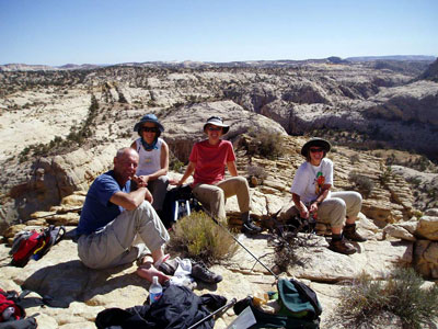
10 AM. We split into groups each day. The first day, the Browns, Opsahls,
Buckendahls, Karen, and Marilyn joined with Greg and Dave Scudder, Arne, Glenn,
and Kathleen from the other trip, for a hike downstream. The group waded through
cold water for about 1/4 mile, but climbed out when they reached a narrows.
Dave's radio slid down the slickrock into the cold water, but he recovered it
with a quick dive. The party split, with one group roping out of the inner
canyon, then hiking up the slickrock to Slickrock Saddle, looking over the top
to Death Hollow, and noting a well-worn cairned trail to the north, which
probably connects to the Mail Trail. The other party waded the chest-deep
narrows, then hiked cross country to the natural bridge (marked on the ma,
seeing a rattlesnake, and red and grey foxes . Bill fished solo upstream to the
Mail Trail, but was somewhat frustrated by the heavily vegetated small stream,
which offered only rare opportunities to cast. He caught 5 brown trout, up to
about 11 inches in length. Ginger and Karl cooked pork loin fajitas, preceded by
guacamole, salsa, and chips as appetizer, while some of us visited the other
camp for margaritas (with ice!).
After dinner, Marie visited our camp to invite us to their campfire. After a
while (perhaps this was the margaritas talking), eight of us thought it would be
a great idea to hike under the full moon. We hiked up the south fork of our
drainage, then scrambled up the slickrock to the ridge above. The views of the
slickrock cliffs and domes under the moonlight were otherworldly. Even Ginger
made it up a friction scramble that might have intimidated her in the daylight.
We sang (or made noises that we thought were singing), howled at the moon, and
danced. Dave Scudder forgot his alma mater's hymn, but Bill did not. After a
false start towards a slope that looked far too steep to attempt at night, we
descended a gentle friction slope that put us in a drainage that, to our
surprise a few hundred yards further, turned out to be our main drainage. All
individuals except one unnamed proved that they could hike and not fall down,
margaritas or no. The unnamed individual completed the hike with the sturdy
assistance of a lovely lady supporting him from each side. The unnamed
individual thought that two ladies were great, and wondered how much more he
needed to drink to get four. The moonlight hike was perhaps the best memory of
the trip, both for its aesthetic and the rowdy good time.
The next day, Saturday, was our second full day, and the last for Kathleen's
group. Bill again fished solo, hiking two hours downstream, to a point not far
above the confluence of Willow Patch Creek, then working his way upstream to a
point not far below the narrows. The stream was significantly wider and easier
to fish than the upstream segment. He caught 20 trout, mostly browns with a few
rainbows, and caught many by casting to a fish that he first located by sight.
The fish were wary, and would flee if they saw him even 20 yards distant, but
would almost always strike a dry fly if they were unwarned. His largest catch
was 13 inches, but bigger fish to 16 inches were easily visible in the clear
water.
The same day, a party of about ten hiked cross-country downstream to the natural
bridge, descending to the canyon bottom. They climbed high on the slickrock,
obtaining a fabulous view of the Sand Creek country. Unfortunately, on the
descent, Karl fell about 4 feet and rolled at least 6 feet more, hurting his
knee enough to confine him to camp the next day. He stepped onto a ledge that
collapsed beneath him. Thanks to his rugby roll, he was not hurt any worse. Karl
finished the hike in a knee brace. The hikers saw Bill fishing below the natural
bridge and waved, but did not meet up with him. The bridge was below a pouroff,
and above a pool which we swam. The vegetation near the stream below was so
thick that the water-gathering party could not find each other.
That night the campfire was in our camp. The ravenous party devoured Karen and
Marilyn's wine, olive, pepper, cheese and cracker appetizers, and beef stew. The
appetizers disappeared from their cans before they could be elegantly arranged
on plates (pearls before swine, we suppose). Karen, ex-nurse, diagnosed Karl's
knee, and determined that the injury was not fatal. She prescribed a heavy dose
of vodka and Crystal Light. he other party took advantage of our campfire to
burn all their toxic waste. Greg Scudder's shaggy dog tale was almost as bad as
the toxic waste. And Bill forgot almost all his blonde jokes, to Karen's relief.
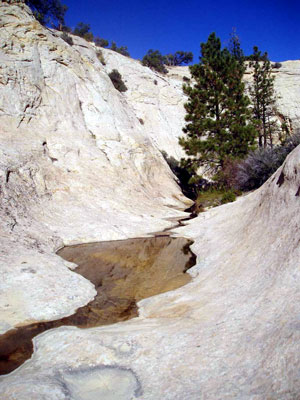
Water in the desert - a
spring-fed drainage that flows into Sand Creek.
On Sunday Bill tore himself away from fishing and led an exploratory hike. He
promised a straightforward hike to Slickrock Saddle, with a further exploration
of the cairned trail. He lied. The party included the Opsahls, John, Karen,
Marilyn, and Ginger. They hiked cross-country to an east-side drainage that
entered just downstream of the narrows. Water flowed from a large plunge pool
for a few hundred yards to Sand Creek. As always, water in the desert made for a
beautiful sight. We crossed the stream opposite the mouth of this side drainage,
and worked our way up to the first bench, through the bushes and a cliffy layer.
The streamside was moist enough to sport mushrooms. The first bench looked like
a dead end, but on closer inspection we found a friction route up from the top
of the talus, and an even better short climb of 6-8 feet that could be protected
by putting one of the guys on each end. Karen took Ginger's questionable advice
and attempted the friction route, which worked well except for some skin lost to
a slide, and a lost hat that John retrieved. Ginger ignored her own advice, and
took the climb with Marilyn. But she performed bravely, climbing without
assistance, through moves that she would hardly have attempted a few years
previously. The Opsahls turned back to camp before the climb.
This party then traversed the slickrock below the multi-fingered point, on the
west side of the creek downstream of camp. They lunched at the tip of one of the
fingers, with a view over the whole Escalante country. The problem now was to
find a way to the mesa top, in order to loop back home via Slickrock Saddle.
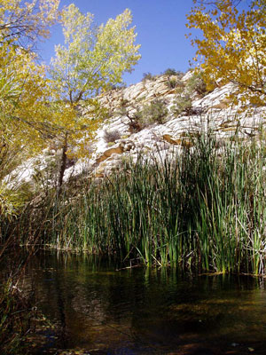
Lunch was at the end of a finger extending
from the mesa, with an
out-of-this-world view.
Descent from the lunch stop eventually required a drop
of about 8 feet from a corner seat. The guys jumped; the ladies jumped onto the
guys' shoulders and were piggybacked to safety, much to the ladies' relief.
Ginger was so worried that she broadcast her weight before climbing on. We'll
never tell! The party thought they were home free, until they came across a
crack that blocked our passage. Bill leaped to the bottom, committing himself to
the passage; Marilyn found an easy walking route to the same destination. The
party worked their way up a gulley and a breakdown slope to the mesa top and a
bird's-eye view of the whole country. The rocky terrain was broken by the bright
yellow cottonwoods at the confluence of Willow Patch Creek.
They hiked north along the mesa top, then descended into the enormous bare rock
bowl of the Slickrock Saddle drainage, fractioning down the gentle slope, then
dropping down a breakdown slope to a water tank for a dip. Everyone swam, even
if they did not linger in the October afternoon. The miracle of the afternoon
was that Karen found her sunglasses at the bottom of the tank, after diving in
with them on her head. The party descended further, passing several tanks, then
cut cross-country to the north, arriving at the canyon edge just opposite camp.
The descent from the bench was easy, but the last ten feet through the willows
cost Marilyn one of her water bottles. Our last dinner in camp was Judy Opsahl's
cashew and basil spaghetti.
Lunch on our hike back to civilization was
in a little glen with a spring-fed
stream.
We split into two parties the day that we broke camp. Karl and Ginger, slowed by
Karl's bad knee, hiked out the way they came in. They met the Cochranes and
their five pack horses en route; Sioux volunteered to bring the gear to the B&B,
so the Buckendahls were free to have lunch at Hell's Backbone Grill, clean up,
shuttle the cars, and meet the rest of the party at the Escalante River
trailhead. Bill led the other eight on a cross-country adventure to the
Escalante. They reached Willow Patch about a mile above the confluence, and had
lunch in a little glen, with a small stream running over moss and rock into a
cattail-fringed pond. The cottonwoods were at their autumn peak. In the middle
of the Utah desert, we found ourselves hiking through a swamp. We followed
Willow Patch nearly to the confluence, then worked our way up and out.
From the top, our first view of Sand Hollow was otherworldly, with a mix of
white and red stone set out in walls, domes, and fissures. A balanced rock was
perched just to the right of our route. We followed Sand Hollow's sandy bottom
downstream, with a view towards following the water through Sand Creek to the
Escalante, but were surprised. Sand Hollow is blocked by a major pouroff in the
red formation. Despite John's optimism, it was impassable, certainly so without
a rope. We abandoned our plan for Sand Creek and backtracked upcanyon, ascending
a ramp to hike below the white dome that is the highlight of Bowington Bench.
The next problem was to find a way down into the dry canyon that parallels Calf
Creek to the west. This was accomplished via a butt slide down a friction slope
that took out Karen's designer pants, and a six-foot step for which Bill had the
onerous duty of helping down all the ladies. On the final scramble to the canyon
bottom, Dave Brown sat on a cactus. The party's sympathy for Dave's plight was
held in check by their general hilarity. After a final small pouroff in this
drainage, the party reached the Escalante and, a few minutes later, the
trailhead. The 7 1/2 hour hike ended with a rendezvous precise to a few minutes.
Expenses were settled at the final dinner. The packer's fee was $1000, augmented
by our 20% tip. The total expense per person was $208, including the bed and
breakfast stay.
The party split after breakfast. Karen, Marilyn, and Bill drove back via the
Burr Trail (2 hours drive, one hour hike near the switchbacks), and caught the
11 AM ferry (every odd hour this time of year) from Bullfrog to Halls Crossing.
The driving time from Hall's Crossing to Los Alamos was 7 1/2 hours. Plans are
already underway for October '04, featuring a 6-night camp at the Willow Patch
confluence. The theme for the trip will be drinks with umbrellas. The prospect
of our future adventure helps temper our sadness at ending this year's trip.
A full copy of this report, with 8 more photographs,
can be obtained by
e-mailing bill@priedhorsky.net