Author:
Bill Priedhorsky
Trip Participants: Bill
Priedhorsky, Marie Caldwell, and Martin Staley
This is a report of a trip to Hideout
Canyon, a tributary of White Canyon, Utah. The trip was advertised as a Los Alamos
Mountaineers trip. However, because there were only 3 participants, too few for
the Mountaineers, we made it a private trip.
Thursday April 1: We left Los
Alamos at about 4:45 PM, stopping at the Three Rivers Brew Pub in Farmington for
dinner, and arriving at the Recapture Lodge in Bluff at about 11 PM. It was
short night, with a meeting for breakfast at 7 PM (standard time).
Friday April 2: Our trip was
based on an April-May 1988 trip to this area led by Hank Blackwell (trip report
available on request). The attraction of Hideout Canyon is its falls, vertical
scenery, and relative proximity to Los Alamos.
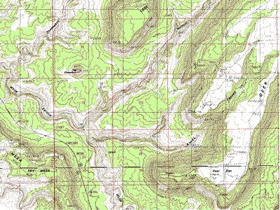
This minute map hints at the complexity of this area.
Following the description of the 1988
trip report, we parked the car about 1/2 mile to the east of milepost 77 on
highway 95, and headed for the canyon rim. We started into the canyon about
10:30 daylight time, following an unrewarding (no breakfast for the public) stop
at Fry Canyon Lodge. The weather was cool and rainy all weekend. In Albuquerque
to the southeast, the weekend included the rainiest 24 hours on written record.
The weather was slightly drier in the White Canyon area, but definitely damp,
leading to several episodes where the waterfalls cascaded from the canyon walls.
We followed the rim on the south side of
the canyon to a point nearly opposite the mouth of Hideout Canyon, then found a
way down through the penultimate layer from the top. This upper and the
lowermost layers of the canyon wall are the toughest to penetrate. We scrambled
down the very brushy slope to the top of the lowest layer. It took some time to
find our way through this; eventually we did so about 200-300 yards down the
canyon from the mouth of Hideout, hiking on a ledge just above the bottom layer.
We did not need a rope on the way down. We did, however, need to hole up under
an overhang during a particularly heavy rain, keep drying for our lunch break.
We hiked up Hideout, worried that the
rain would intensify and lead to a flash flood. As we hiked we were careful to
keep track of escape routes. We needed a campsite well above the canyon bottom.
Eventually, about 45 minutes up the canyon, we found a deep alcove on the north
side of the canyon. The back of the alcove was perhaps 50 feet past the edge,
and 15 feet above canyhon bottom. There was a large flat space for camping, and
no chance of getting wet, either from the rain or the stream. Firewood was
everywhere. In any drier weather, water may have been a problem. But this time,
there was a pool of water just below the camp. The alcove faced north, and never
saw the sun.
Once settled in camp, I hiked up canyon
to look for the blocking waterfall. The rain started in earnest, and little
waterfalls could be seen in every direction. I enjoyed the sights, then hurried
back to the safety of our alcove.
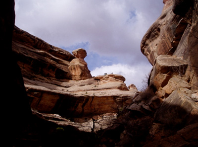
View from the canyon near our camp, which lies opposite
the mushroom feature.
Saturday April 3: Like many first
nights in camp, I slept well, catching up from the short nights of preparation
for the trip. It took until about 10:30 am to set out from camp (we set our
watches to daylight time immediately upon entering the canyon). We hiked up
canyon to an impassable waterfall about 1/2 hour above camp. Backing down canyon
a few hundred yards, we found a way up on the right (east) side. The first two
pitches were led by Martin. Marie and I were grateful for the assistance of a
rope, which gave some security on the steep friction slopes. We had lunch under
a jutting outcrop, then made our way along the contour up canyon. This involved
a traverse along a ramp that was about as wide as a sidewalk, and above a very
substantial drop. From the other side of the canyon, this route looks
impossible, like a sheer cliff face, but it is not really hard. We found a route
to the top, and headed east across the top to the west branch of K&L canyon.
Finding a way into K&L meant a detour to the very top of the canyon, just below
the red bluffs that surround the top. The route down K&L involved bypassing 3
waterfalls. The first could be bypassed on the east side, sliding down a rock
slope into a grove of trees. The second required a rappel or slide directly down
the dry waterfall (a little scary with thunder in the background). The final
waterfall, below the junction of the two branches of K&L, was bypassed with a
trail of about 1/4 mile on the east side.
As we hiked down the lowest parts of
K&L, we saw a flock of about 5 bighorn sheep high on the wall of the canyon. The
short piece of White Canyon between K&L and Hideout showed clear signs of the
late summer 2003 flood, which stripped the vegetation to 15 feet above the
canyon bottom. By the time we reached camp, it was well after 7 PM. We ate well
every evening, thanks to Marie's clever casseroles, like pesto and chicken. The
nights were cool, but a campfire kept us warm.
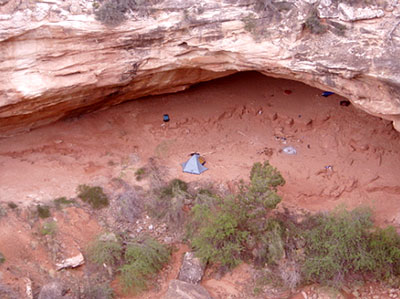
View of camp from above, showing our well-sheltered,
north-facing alcove.
Sunday, April 4: After our tiring
adventure of the previous day, we were in the market for an easier day. We hiked
down canyon about 1/4 mile, and explored for ways to the top. There was a
straightforward climb through the tough lowest layer, but the immediate routes
to the top did not go. After the three of us ate lunch on a ledge, enjoying the
view of the canyon, Martin and I headed up canyon to see whether a thin-looking
corner went. Surprisingly, it did. Martin went up the easy route, not noticing
the exposure until he passed it. I went up the harder but less exposed layback
on the right side of the crux. We climbed to another layer, up a big boulder
that required a little hop to the ledge, and after another hundred yards up
canyon found ourselves just opposite camp, below our mushroom landmark. Our
photograph of camp was taken from this point, on a ledge two levels below the
top. We found a set of footprints heading up canyon, which disappeared up a
steep (5.7-ish) upwards climb. We were surprise to find that the ledge went for
well over a mile, to the west-side side canyon near the top of the attached map.
There were routes that looked promising to the top, but nothing reasonable went
to canyon bottom. We passed yesterday's blocking waterfall, then two more.
Passage through the central regions of Hideout Canyon would seem to require a
technical rappel through this unclimbable section. Marie enjoyed a quiet
afternoon in camp.
Monday, April 5: We awoke to the
sound of rain and waterfalls coming off the canyon walls. There must have been
at least two dozen waterfalls, large and small, along our route to White Canyon.
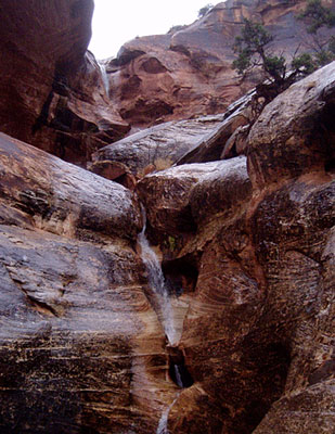
The largest was at the bottom the west-side drainage, clearly visible on the
map, shown in the photograph below. When Martin reached the bottom of White
Canyon, he crossed with dry feet. Marie and I were hiking about 100 yards behind
him, and had to wade through 6 inches of water. White Canyon had just started to
run - Martin was ahead of the nose of the stream, while we crossed behind it.
The nose moved slower than walking speed, so we passed it as we hiked down
canyon, and hiked most of the way to our exit in the dry canyon bottom. As we
climbed out, however, we watched the stream filling beneath us. There were a
couple of tough spots, but brave Martin climbed them pack and all, and lowered
us a rope. By the time we were opposite Hideout, it was running strong, filling
the lower section that we had hiked on the way to White Canyon. Instead of
returning the way we entered White Canyon, we found a diagonal route from one
ledge to the next, slowly working our way up towards the point opposite Hideout.
This avoided the steep chute at the top, but was as thrashy a hike as I ever
have done, in the thick vegetation on this north-facing slope. The top of the
canyon was wet and cold, with some real mud. Getting into the car was a bit
acrobatic as we struggled not to drag in too much of the gooey clay. When we
turned on the car, its thermometer explained why I was close to shivering. The
temperature on this fine April day was 38 F, and snow showed on the upper slopes
of the buttes to the north of Hideout. The trip from camp to car had taken about
3 1/2 hours. With a stop for lunch in
Bluff and a dinner stop at the Abiquiu Inn, we arrived in Los Alamos at about 8
PM.