Author: Bill Priedhorsky
Trip Participants: Bill
Priedhorsky, Dave Scudder, Allyn Pratt, Francesco Grilli, Kathleen
Gruetzmacher, Linda Klosky, Jan Studebaker.
Photo Gallery:
Jan
Studebaker,
click here.
Sunday, October 9, 8 AM:
We are 5.4 miles into the
wilderness, settled down to spend a week at a site established by Red Rock
'n Llamas. Our camp is on the west side of Death Hollow and below the
summit of Anton Ridge. Today we are well-rested - our camp circle broke up
at 8:30 last night, a full 11 1/2 hours ago, so there was time to catch up
from the short nights of packing and traveling. With a small party of
seven, diminished by family emergencies and health, we were able to move
fast. We left the motel in Torrey at 6 AM yesterday morning, drove through
Boulder at 7 to find no breakfast spot open, but found a sturdy breakfast
and an interesting bookstore, the Roan Pony, in Escalante town. We arrived
at the Escalante trailhead for the Boulder Mail Trail at 9 AM, just a few
minutes before Bevin, BJ, and their 9 llamas from Red Rock 'n Llamas
arrived to load our gear. Even with 2 extra llamas we were squeezed,
perhaps because we were prepared for cold weather and a long trip. Bevin's
llamas are not especially large, and can carry a gross load of 80 pounds
apiece.
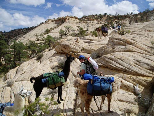
Backpacking without
backpacks: llamas from Red Rock 'n Llamas carried out loads to a
wilderness base camp. Kathleen (foreground) and Linda (background)
leading
llamas up the Antone Ridge monocline.
After packing we left at 10:30 and
hiked directly to camp, arriving at 1:45 PM. Our camp was a spacious flat
with a mix of pinons and ponderosa trees, above 3 pools in the unnamed
drainage that heads toward Emerald pools. The afternoon was quiet as we
set up tents, guying heavily against what looked like an oncoming storm.
Dinner was Al's spaghetti, and we were too tired to bother with a
campfire. After dinner we scooted up the bluff north of camp to see our
site laid out below and the sunset clouds.
The day before 7 of us crowded into two cars to save $3 gasoline,
meeting at my house at 6:30, leaving Jan's in the Jemez at 7:45, and
arrived at Leprechaun Canyon at 3 PM for 90 minutes of hiking. We did not
hike past the wet narrows. We arrived in Torrey at 6:15, staying at the
Best Western Capitol Reef, and had a magnificent dinner at the Cafe
Diablo.
Monday, October 10, morning:
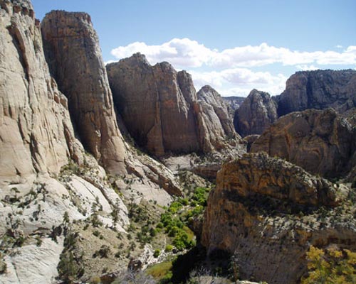
View into Death Hollow,
the deepest canyon in the vicinity, with a year-round stream
and dense
vegetation - but too cold a place to camp this time of year.
It was windy all night but calmed
this morning. Yesterday, we set out at 10:30 AM after Linda's recital of
her adventures with the Australian aboriginals who name her Linda Napiljari. We crossed the west end of the bluff north of camp into the
drainage of Mamie Creek. Hiking downstream we reached Mamie Natural
Bridge, which frames the pool below. There were a series of pools farther
downstream, then a 300-foot (?) dropoff into the final deep run of Mamie
Creek. We explored the north side of Mamie to a viewpoint above its
confluence with Death Hollow, found no easy way down, then backtracked to
the dropoff for lunch. Afterwards, Jan, Bill, Dave, and Franceso climbed
surprisingly passable ramp and gulley to the cliff top, and a castle above
the southwest corner of the confluence. We recovered nicely from our hike
in camp, with sun showers, Francesco's pasta carbonera, and a wind-driven
fire, hot enough to melt glass and burn aluminum. Around the fire we sang
girl rock and the Righteous Brothers, and finished the first chapter of
Edward Abbey's semi-autobiography, "A Fool's Progress".
Tuesday, October 11, morning:
The wind has died, and the clouds
are gone, so the night was cold. None of us exited our tents until the sun
hit, right at 8:00 AM. The sky was a fantastic sight at 5:30 AM, with the
band of zodiacal light rising from the direction of the imminent sun, and
pointed towards an intersection with the band of the Milky Way. Thoughtful
examination showed three axes of rotation represented on the sky: the
Galaxy around which we circle every 200 million years, the zodiac around
which the planets rotate, and the Earth's spin every 24 hours.
The wind was still strong yesterday
morning, and the sky clouded over by afternoon but cleared by evening.
Bevin had warned us of possible snow, but there was not a drop of
precipitation anytime this trip. We arrived in camp late yesterday
afternoon, and wiped down with a washcloth rather than take showers.
Our hiking objective was to explore
the mass of slickrock to the northeast. The terrain is fantastically
complex. When we climbed the peak that we had targeted for lunch, we found
ourselves a mile from our intended destination, according to the GPS. Our
hike started up our drainage to the old Mail Trail, and followed the old
steel telegraph wire - a single strand - to the bottom of Mamie Creek. As
we hiked up Mamie, bypassing deep side canyons to the north, the canyon
bottom changed from sand to ponderosa and needles, with pools at regular
intervals. We found an aspen grove of a dozen trees, still green in
mid-October.
From Mamie Creek we turned to the
north along a tributary, then took a false turn to the west on what we
thought was a main drainage, but was not. Scrambling along the edge of a
ridge we reached the red summit of our lunchtime peak. Descent took us
past a foot-soaking pool - too shallow to swim, but full of flies that
flew in water, not air. Jan, Dave, Francesco, and I found a route down a
steep side canyon, then down a tree for the bottom 8 feet - a tree that
was ready to hinge at its base and polevault Dave, our free climber, to
the canyon bottom. The rest of us were belayed. We returned to camp by 6
PM, 8.7 miles showing on the GPS odometer.
Wednesday, October 12, 9 AM:
Yesterday we hiked into big canyon
country, looping 5.2 miles downstream from our camp. We followed our
drainage from one pouroff to another, detouring to the side as needed. One
detour was to the left side, facing downstream, then down the nose between
our creek and its main tributary to the west. Another diversion went up
and down the pillow-texture slick. It was not warm, but Bill, Dave, and
Kathleen took a bath in the icy pool below, while the cowardly watched.
The pouroffs became larger and more frequent as we descended the canyon,
and it opened to bare rock. By working down from the plateau above the
Death Hollow confluence and traversing a final set of pools, Dave and
others reached a point directly above the Emerald Pool in Death Hollow.
Linda was belayed for the final traverse. Our return was along the flat
island between our drainage and Death Hollow, with big views in both
directions.
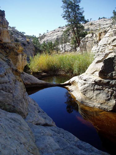
Our unnamed drainage
nestled one beautiful pool after
another on its way to the Emerald Pool
and Death Hollow.
Thursday, October 13, 9 AM:
Today dawned cloudless and chilly,
if not as hard a freeze as a couple days ago. The sky was clear enough to
be worth waking up at 4 AM for stargazing. Two hours before the earliest
signs of dawn, the zodiacal light was prominent in rising Leo. I was
excited to see, for the first time in my life, the Gegenschein - the dim
broad patch of light, perhaps 10 x 20 degrees, due opposite the Sun on the
sky, caused by sunlight retro-reflecting from grains of dust in the plane
of the solar system. Linda and Kathleen were the only ones hardy enough to
wake with me.
Yesterday we hiked up the drainage
in which we are camped, exploring the north fork. We passed the usual
beautiful pools, and belayed a thin traverse above one of them. We climbed
out of side canyon and had a second lunch on peak 6916, past a sharks-fin
protuberance, to views of slickrock for miles to the north. I cannot
remember seeing such a large expanse of slickrock before. We traversed the
upper end of the north fork, past two large crevasses that we named
"Kathleen's cleavage", and returned to camp on a miles-long slickrock
slope. Bill found a place to splash on the way out of the crevasse, then
all had a shower at camp, for once warmed by the sun showers. Linda's
curry made an exceptional dinner.
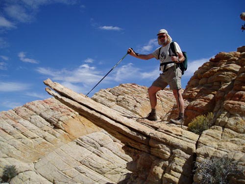
Fearless leader on the
shark's fin, climbing peak 6916 on the way to lunch.
Friday, October 14, 9 AM:
We were up again at 6 AM to see the
sky. The zodiacal light rising in the west was the most prominent feature
in the sky, rising at least 45 degrees up from the horizon.
We have had a campfire every night
except our first. This is allowable in the uplands in the National
Monument, although not in the canyon bottoms. For three nights I had
started the fire with one match and half a paper towel. Challenged by
Linda to do better, Francesco and I last night made a fire with no matches
and no paper, finding a coal still hot from the night before, and using
pine needles for tinder.
Yesterday's hike took us north
across Mamie Creek, climbing one knob after another and finishing with
peak 6630 overlooking the Mail Trail-Death Hollow intersection. The climb
up 6630 involved a series of traverses along sloping ledges over big
exposure. Linda was uncomfortable at the top, hoping for an easier way
down. There was none, but she watched her feet one step after another and
descended without mishap. We followed the Mail Trail back to camp.
Saturday, October 15, 6 PM:
We are out of the canyon and in
Boulder town. Sadly, civilization is still here. Our last hike as a full
party was yesterday. Augmented by Greg Scudder and Greg's friend Kelsey,
we headed up the south fork of our drainage. Not far above the Mail Trail
we encountered an aspen grove in gold, and a tangle of berry thorns. We
climbed the slickrock on the south side, and scouted a route up a high
point that was an outlier of Antone Ridge. This was our viewpoint for
lunch. We worked below and along a very rough ridge, and split our party
near the top, with Allyn and the Scudder party returning to camp. Just
after starting back, Kelsey sprained an ankle, but was able to hobble back
to camp, and hiked out the next day not much slowed.
The rest of us topped Antone Ridge
and saw the view to the west over Escalante town, including the incredibly
convoluted view of the ridge monocline. We returned down a long slickrock
ramp, and across the flat part of Antone Flat. Dinner was Dave's
potato-leek soup, with fresh ingredients.
Today we woke at 7, an hour before
the Sun hit out tents, to pack for departure. We worried not only about
Kelsey's ankle, but also Greg's sudden illness. One party went out with
them at 10 AM; Jan, Allyn, and Linda waited for the packer, who arrived at
1:45 rather than the promised noon. The gear party arrived at the motel by
6:30 PM. Franceso, Kathleen, and I hiked out the long way on the Mail
Trail, crossing Mamie Creek, Death Hollow, and Sand Creek, for a run of
about 10 miles that took us from 10:30 to 4:30. The bottom of the Hollow
was dark and full of colored vines and trees - we weren't sure which were
poison ivy, but we were suspicious. Sand Creek was a mess, showing signs
of recent flooding. The Mail Trail has been re-routed, with a new starting
point near the parking area, rather than down the dirt road to McGath
point. Despite worries about the load, the late packer, and injury and
illness, everything came together for a successful trip ending, which we
celebrated with dinner at the Burr Trail Grill - served by our llama lady,
Bevin.
Copyright Bill Priedhorsky
2005