Leader and Author:
Jan Studebaker.
Participants: Kathleen Gruetzmacher
with daughter Elena, Bill Priedhorsky, Jackie Little, Ron Morgan,
Jan Watson, and Jan
Studebaker.
Jan's Annotated Slideshow:
click
here.
Satellite View: click
here.
Google Earth:
click
here.
Map with
points of interest: click
here (play with the options).
Paper Maps:
Toltec Mesa 7.5 Quadrant USGS Map, and Cruces Basin Wilderness USFS
Map.
I had been planning to do a backpack
trip to Cruces Basin Wilderness for several years, but the right
time never seemed to arrive. In the meantime I talked to friends
about the area, but few had even heard of it, and no one had done
more than a day hike or a look into the basin from the dirt access
road at 10,000' that overlooks it. It was finally time to explore
this beautiful and unique area on the New Mexico/Colorado boarder
near San Antonio Mountain.
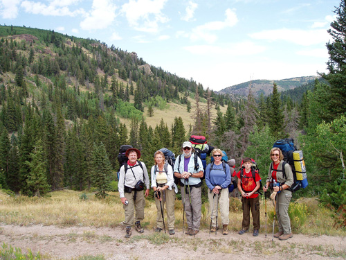
Ron, Jan (girl),
Bill, Jackie, Elena, and Kathleen. Jan (boy) is the
photographer.
Cruces Basin is much like a huge funnel bordered by high rocky ridges. The
canyons of Diablo, Beaver, and Cruces creeks drop down from the west
to join near the center of the basin. Two miles below, and east, of
the confluence of the three primary creeks, Beaver Creek plunges 800
feet through a truly spectacular gorge in Osha Canyon to join the
Rio de Los Pinos in the bottom of the Toltec Gorge. The
Basins surrounding ridgeline roughly define the wilderness
boundaries.
The
Basin has no maintained trails or signage; however, the canyons
which generally have crystal clear creeks (filled with wild brook
trout) can be used to lead the way, as can the surrounding
ridgeline. Bill was happy with the fishing, but
generally hiked with the group instead. He plans to go back
and make up for lost time. We slept
at around 9000' in September, so a tent and three season sleeping
bag were in order. This is generally considered the best time
of year to visit the Cruces Basin.
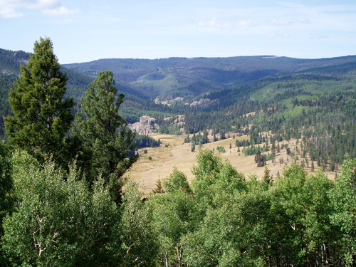
One of many
beautiful meadows in the Cruces Basin.
On the
first day we drove to the trailhead, backpacked in about 2 miles
(~500' vertical) and setup camp on Beaver Creek just east of the confluence of
the three primary streams. Our first day
hike took us west to a high spot near camp for a grand view, our second
day hike took us to the top of Toltec Mesa and an aborted attempt at
reaching the Rio de Los Pinos through Osha Canyon. The
final day hike was a fairly thorough hike along and above Cruces Creek.
Our fourth day was an easy backpack out and
drive home, with a well anticipated stop in Ojo Caliente for Spanish
food.

Bill examines a deep frigid pool before taking
a quick dip.
Getting to Cruces Basin via 25 miles
of dirt and gravel roads is one
reason that the wilderness is not frequently visited, but it is
definitely worth the extra effort! From Tres Piedras go north about
11
miles on US 285 to FR 87. Turn west and follow FR 87 through several
junctions, passing FR 87A in about 21 miles. A mile beyond FR
87A, turn right onto FR 572 (a rough road dropping downhill
from the basins rim). Park within the next two miles (at the top if
you are driving a passenger car), and hike the old road/trail to the
canyon bottom (from 1 to 3+ miles depending on where you park).
This route roughly follows Osha Creek.
Low clearance vehicles require special care when driving here, but
passenger cars with reasonable clearance can make it. Roads might be nearly impassible in some
places if mud or snow were present.
Notes: Be sure to view
Jan's annotated slideshow to gain a better appreciation of our wonderful New
Mexico 'backyard', and it's potential for an easy going and beautiful
adventure.
Also, Jan repeated a variation of this
trip on July 15-19, 2010, resulting in the following new slideshows:
Dennis's annotated slideshow and
Jin's annotated
gallery Again on May 27-30, 2011, Jan went to the Basin on
Devin Close and Bill Priedhorsky's trip which produced
Dave Gemeinhart's slideshow.