Los Alamos Mountaineers
You are here
Muley Twist /Muley Tanks horse pack
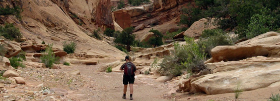
Lower Muley Twist Canyon (Park Service photo)
We had a wonderful trip to the Hall’s Creek Narrows area of the Waterpocket Fold in May 2014, and would like to return to the Waterpocket Fold in the spring of 2015 (Dennis’ photos of the 2014 trip can be found here.) Our next trip (May 9-17, 2015) will be a horse-supported expedition to the Muley Tanks oasis, which gives us access to the lower end of Muley Twist Canyon and some fantastic sculpted terrain along the Waterpocket Fold. I have no doubt that we can spend our 5 wilderness days exploring one surprise after another.
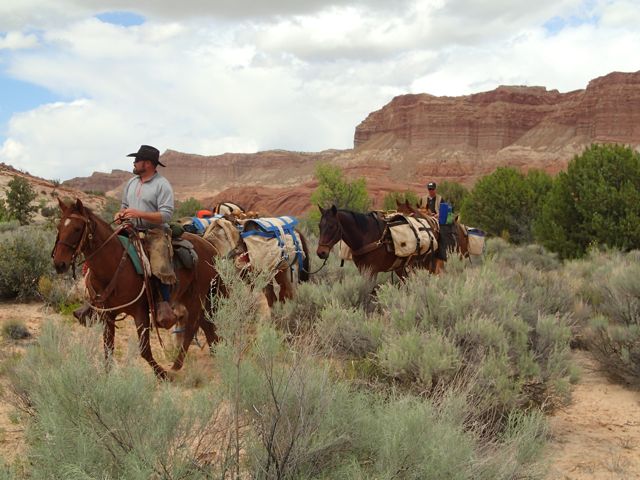
Like last year, we will employee the services of Cody Clapp to pack our gear into camp. The packing charge will be $550 per person, same last year. Because we will be in Capitol Reef National Park, we must use horses, not llamas.
The trip will run as follows:
Saturday May 9: Leave Los Alamos and drive to Torrey, UT, picking up a permit at Capitol Reef park headquarters.
Sunday May 10: Meet the packer at The Post trailhead; accompany him 6 miles south to our camp, setting up in comfort with tables, chairs, and wine cellar.
Monday-Friday: Day adventures along the Waterpocket Fold and Muley Twist.
Saturday May 16: Break camp and hike out; overnight at TBD location, perhaps Bullfrog Marina.
Sunday May 17: Drive back to Los Alamos.
A large mosaic map of valley from the trailhead south to camp can be obtained here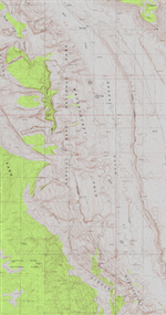
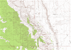
and another of the valley on south to Brimhall Arch can be obtained here.
To reserve a spot, please send a deposit of $200 to Bill by bank transfer or check. The trip will be capped at 12 participants.
- Log in to post comments
Theme by Danetsoft and Danang Probo Sayekti inspired by Maksimer
Comments
Trip Report, Waterpocket Fold May 9-17, 2015
This is a report of a week long horse-packed trip to a camp near the confluence of Hall's Creek and Muley Twist Canyon. We went because of the spectacular scenary, and were not disappointed. The Waterpocket Fold is a place where the Earth is turned almost upside. Our horse packer was Cody Clapp of Torrey, Utah, and we would recommend him for his diligence and reliability. He can be reached at cody@backcountryoutfitters.com or mobile (435) 691-2639.
This area is in Capitol Reef, which necessitated interaction with the National Park rangers. They came across as difficult and unwelcoming, not the kind of rangers who welcome you to come share the park that all of us Americans own. A particular difficulty was the backcountry permit, which cannot be obtained in advance by phone or mail, but can only be picked up in person at office hours of their convenience. This made advance planning worrisome, but after listening to the rangers' lecture, we indeed received the permit that we needed.
May 10, Sunday
Hiked into our Muley Tanks camp. We had overnighted in Torrey, Utah, and left the gas station near the junction with the Boulder Road at 8:45 AM. Arrival at The Post trailhead was at about 10:20, and we started hiking at 10:50. We stopped at the Cottonwood Tanks for an explore, hiking up the drainage to some of the upper tanks, then turned off trail to follow Hall’s Creek into some narrows. We arrived at camp by about 3:10 PM after an 8.0 mile hike, and Cody followed about 3:45. He hadn’t left the trailhead until about 2 PM. It took hours for him to saddle and pack. We made camp in the flat somewhat below the lower tanks.
It is always a relief to see the packer arriving at camp with our gear
May 11, Monday
We left camp at 10 AM for our first hike, and climbed up the drainage past Muley Tanks into the first canyon along the sky line above camp. We found it to be thickety and bouldery, so we contoured to the south until arriving at the edge of a huge canyon for lunch. After lunch, we climbed up to a view to the west, looking into a canyon that paralleled the main Halls Creek. The route down the face was a little tricky, but dropped us onto the main canyon bottom, which followed home until arriving at camp about 4 PM.
May 12, Tuesday
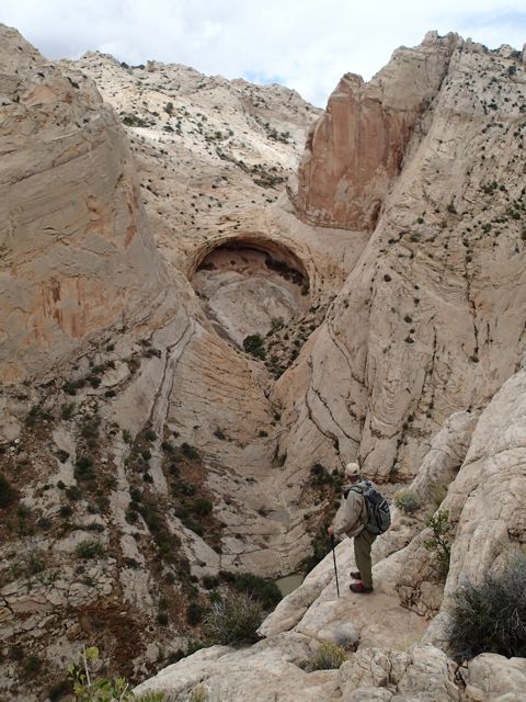
We explored the drainage south of Muley Twist, which we called “Pseudo Muley Twist”. This drainage hooks to the south, following a path that takes it west of our camp. It was only 0.3 miles from camp to the confluence, so we reached it soon after our 10 AM departure. We quickly ran into a narrows, which we detoured by hiking north onto the rise, then after some back and forth dropped back into the drainage once again. We were not able to stay in the drainage long, but were blocked by narrows and pools, and climbed out to the west. Across a short divide, we found a view into Muley Twist itself. The party split at this point, and Patti, Lorrie, Chris, Terry, and Kathleen headed back to camp, but not before exploring the lower part of Muley Twist.
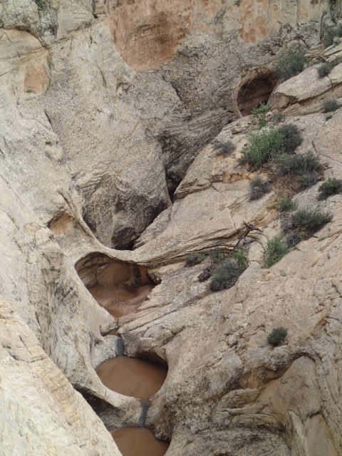
Our lunch spot was the amphitheater in the middle of this photo, seen from above three days later.
The rest of the party followed along the west side of “Pseudo Muley Twist”, above the steep and narrow canyon, and found a way back down to the stream again. Lunch was in an amphitheater on the north side of the stream, reaching by a little scrambling up a side drainage. After lunch we continued upstream. We were nearly stopped by a knee-deep pool, which we thought was the entrance to another set of impassable narrows. Instead, there was only one pool, then the canyon opened into a huge space at the bottom of the “Muley Ear” sandstone ramp. We continued upstream and found a route out to the east, through a gap, which required a belayed climb up a rib – Mary led – which to our pleasure and surprise took us to the first canyon that we checked out yesterday then directly down to the pools and camp.
May 13, Wednesday
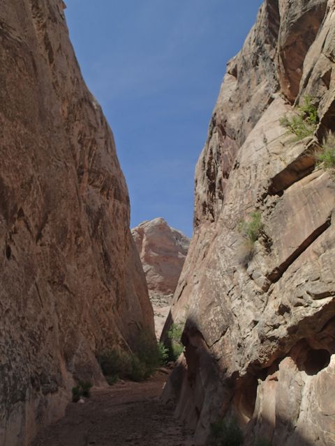
We moved camp in the morning, as required by Park Service regulation. We then left at 11:15 AM and hiked to the canyon to the south. The narrows going into the wall were nice, and we saw a spectacular hogback jumble looking up the canyon branch to the south. We hike the through canyon to the bottom of the steep dirt terrain behind the rocks, which climbed to the top of the Waterpocket, seeing some cap rocks on dirt pillars. The branch that ran south of our Monday lunch spot, although very deep was a disappointment – brushy, bouldery, and hot. Our hike there and back was along the hard pan on the dry Hall’s Creek.
We explored one of the many spectacular narrows that penetrate the Waterpocket Fold.
May 14, Thursday
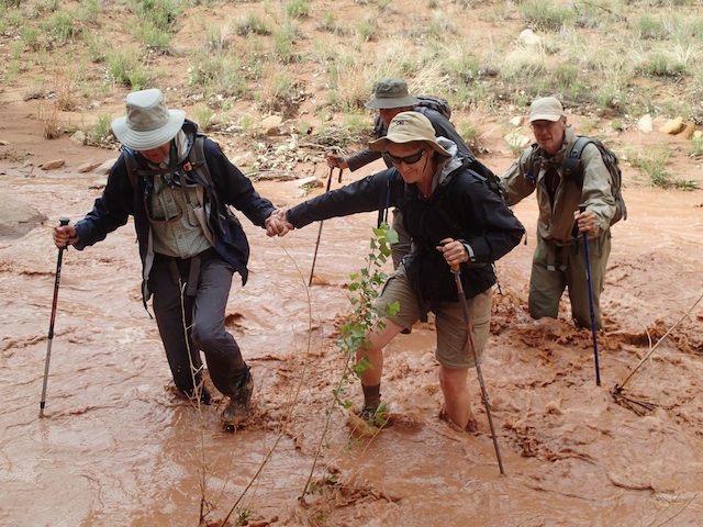
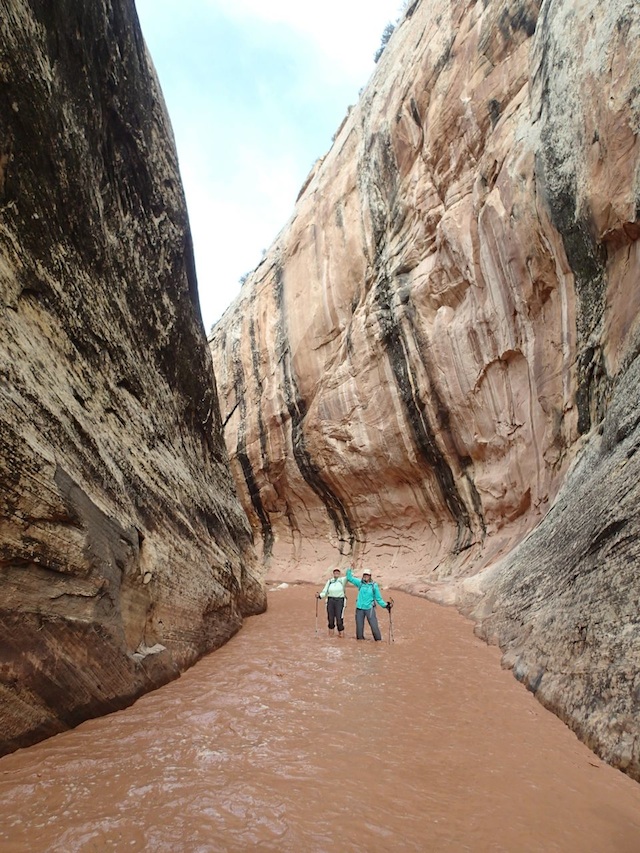
A violent wind storm blew up at 7:30 AM, just after I was up. The sun dome was nearly flattened. My tent pulled out all of its stakes and I held on for dear life as the wind tried to blow it away. Dennis rescued me my putting in some stakes. The wind was followed by heavy rain, and the slickrock flowed into tents. Things dried out a bit and we headed to Muley Twist at 11:15. Five of the party turned back after the lower narrows. The rest reached a turn around point – an alcove with a passage out the back – just as heavy rain hit. We staying there an hour and a half watching the waterfalls come down from the canyon rim. Lorrie guided us back, crossing the chocolate-colored flooded stream 15 times, and we arrived back in camp by 5:30. The rest of the part was rather glad to hear us when we called in from the mouth of the canyon. They had had their own day of adventure, waiting out the floods for more than an hour while the arroyos run hard. It rained once again in the middle of the night.
Crossing the chocolate waters.
Wading out through the narrows.
May 15, Friday
After last night’s heavy rain, we left camp at 10 AM. One party tried the hike to the south to Brimhall Arch, but turned back for fear of bad weather. A party of six – Bill – Karen, Jan, Mary, Stuart, and Toni – traveled northwest on the slickrock, following the bottom of pseudo Muley Twist. We saw pools, a natural bridge down at stream level, and huge views up and down the drainage. We then climbed up a ridge that was to the east of, and above, our amphitheater of Tuesday’s lunch, had lunch and continued contouring to the south below the ridge, and up to a gap that offered a view to the west as clouds came in. We could see the “Muley Ear” sandstone ramp, but dropped down quickly for fear of the weather. It rained heavily once again at 3 AM, but cleared by morning so we could get up at 7 AM and prepare for the hike out.
Natural bridge and pools in the “pseudo Muley Twist” drainage.
May 16, Saturday
We left camp about 10 AM with no packer in sight. Had lunch sometime around noon, and finally saw him just as we were approaching the cars. He was just heading out to pick up our gear. We took about 3 hours to hike out the 5.3 miles, directly up the valley – bypassing the narrows that we took the previous Sunday. It was not until after 9 PM that Cody finally dropped off our gear in Torrey.
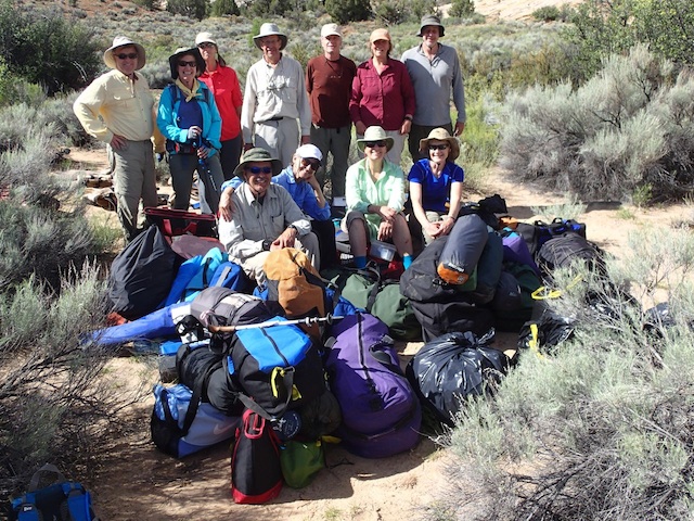
Our party and our pile of gear.