Past Trips
Recent past trips follow. For really old trips, go here
Spruce Hole X-C Ski
New snow at Cumbres Pass, let's go X-C skiing! This is an ~8 mile out/back ski, starting at the Spruce Hole trailhead. Elevation gain ~800 ft. The weather looks good on Saturday, so we should have beautiful views of the Blanca massif.
Bring lunch, water, layers of warm clothing, radios if available, skins if available (probably will not need).
- Read more about Spruce Hole X-C Ski
- Log in to post comments
Learn to X-C Ski or Snowshoe this Winter!
Would you (or folks you know) like to learn to X-C ski or snowshoe this winter? Let me know, and we will schedule dates that you can go!
For X-C skiing - we will travel to the Enchanted Forest X-C ski area, located just east of Red River, NM. The ski area has rental gear, instruction, and packed trails. For a description of the area, and prices, go to http://www.enchantedforestxc.com
- Read more about Learn to X-C Ski or Snowshoe this Winter!
- Log in to post comments
Skiing at Sipapu
sunday Sunday SUNDAY!
Join Zack and Dan at Sipapu ski area on Sunday, Dec 7 for fun and informal downhill skiing. Sipapu has more than its fair share of snow this year -- 22" base depth with more likely to come this week. Lifts are open all the way to the top.
- Read more about Skiing at Sipapu
- Log in to post comments
Dixie Creek X-Country
Hi folks,
Come join me in the SNOW! There is 22" of snow (16" FRESH snow!) at the Cumbres Trestle SnoTel site... I think that snow needs some fresh tracks!
We'll leave the White Rock "Y" at 7:30AM on Saturday morning, pick up Santa Fe ites at 8:10 at the usual NNMC parking lot (Espanola), and be in Chama at roughly 10:00. We should be on skis by about 11AM.
Please dress warmly, bring lunch and snacks.
Please email if you're interested, rgmorgan@lanl.gov.
No dogs please.
ron
- Read more about Dixie Creek X-Country
- Log in to post comments
Winter is on the way...Please keep our homeless folks in mind!
Jan Studebaker and I recently cleaned out our respective gear closets and came up with six sleeping bags, five Thermarest-type sleeping pads, three sleeping bag covers/bivy sacks, and 20+ back packs and day packs, all perfectly functional but not currently in use (believe me, we have plenty of other, newer gear!). Our excess items went to St Elizabeth's Shelter on Alarid St, Santa Fe, but other homeless shelters also welcome camping and outdoor gear (the staff distributes it to clients). Homeless folks can also use your old sweaters, jackets, and boots.
Stone Lions hike or Frijoles Canyon hike (Bandelier Nat'l Monument)
Due to trail closure above the Upper Crossing - the Stone Lions hike will have to be done as an out/back hike from the Visitor's Center. This is a 13 mile hike, net elevation gain is 2850'.
If participants prefer - we could do the Ponderosa Campground/Upper Crossing/down Friloes Canyon to the Visitor's Center. This is ~8 mile hike, with a net loss of 1300'.
Both are 8 hour hikes.
Bring lunch, 2 quarts water, rain jacket, hiking shoes.
Moab hike/bike Nov. 6-11
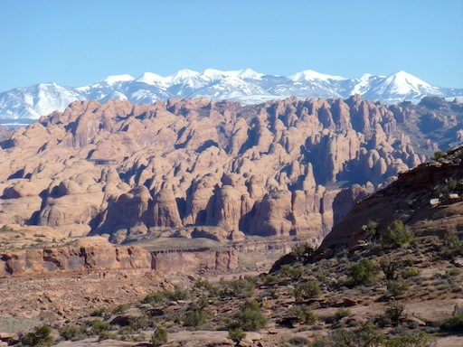
Behind the Rocks, a maze of fins and canyons just over the hill from Moab, is in my experience about as spectacular as any part of the canyon country. See here and here for trip reports.
Update Feb. 27: Room is still available on this trip.
Dear Mountaineers,
- Read more about Moab hike/bike Nov. 6-11
- 1 comment
- Log in to post comments
Community Service Opportunity - Diablo Canyon Trail Work and Crag Cleanup Day
Join the New Mexico Climbers Resource and Advocacy Group (NMCRAG) and the New Mexico section of the American Alpine Club (AAC) for a trail work and crag cleanup day at Diablo Canyon outside of Santa Fe. We will meet at the main Diablo Canyon parking area/campground on November 2nd at 9am.
Chaquehui Canyon exploration
There is a lovely canyon, between Ancho and Frijoles, that allows an access to the Rio Grande - Chaquehui Canyon. Let's explore the trail from the Bandelier overlook to the Rio Grande via Chaquehui. The trail begins at the overlook on the road into the Bandelier Park headquarters. The Park Service tells us that the trail is brushy - so long pants are a great idea. When we get to the river, we will do some exploration along the river. We will return by the same route.
- Read more about Chaquehui Canyon exploration
- Log in to post comments
Ancho Canyon to Red or Blue Dot Trail Hike
Let's hike down to Ancho Rapids in White Rock Canyon on the Rio Grande. The hike begins from State Route 4 south of White Rock, on the Ancho Springs Trail, then proceeds upstream along the Rio Grande, and then finishes hiking up the Red or Blue Dot Trail to Pajarito Acres or the Overlook Park in White Rock. The hike is 1100 ft of elevation loss/gain.
- Read more about Ancho Canyon to Red or Blue Dot Trail Hike
- Log in to post comments